Smarter Cambridge Transport updated proposal
Since the new design for the Girton Interchange is now fixed, we have updated our proposal to fit around what will be built over the next few years. The two key objectives for us are:
- Connect the A428 directly to the M11 in both directions, taking traffic off the heavily congested A1303 (Madingley Hill).
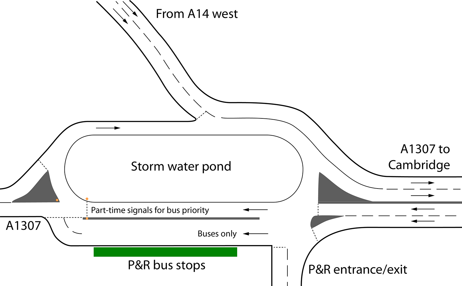
- Provide a new Park & Ride site at the Girton Interchange, serving traffic arriving from the west on the A428 and from the north-west on the A14.
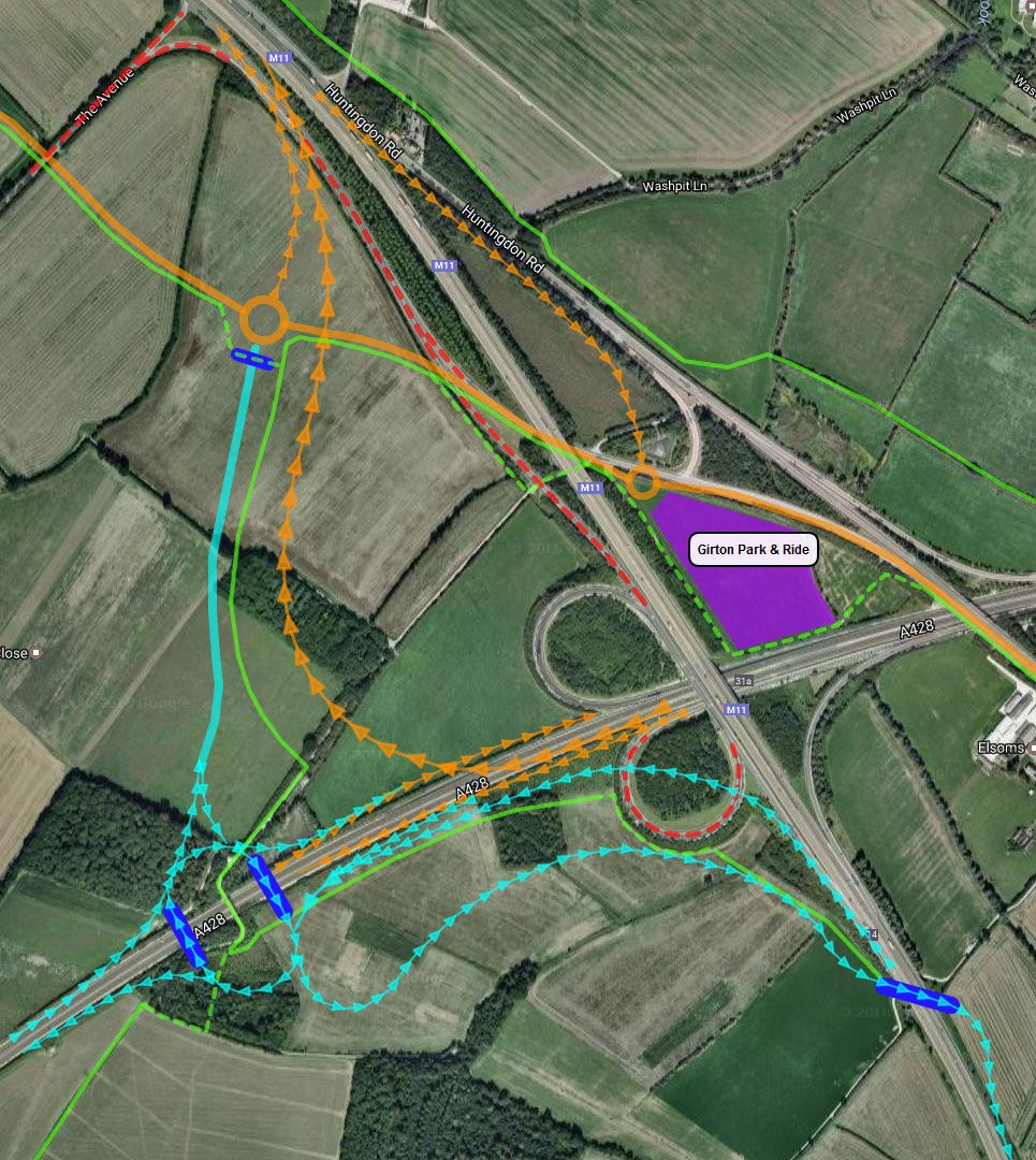
This rough sketch (which should not be taken to be geographically or technically precise) shows how these objectives could be met with the minimum of land take, and preserving or enhancing cycle/bridleways:
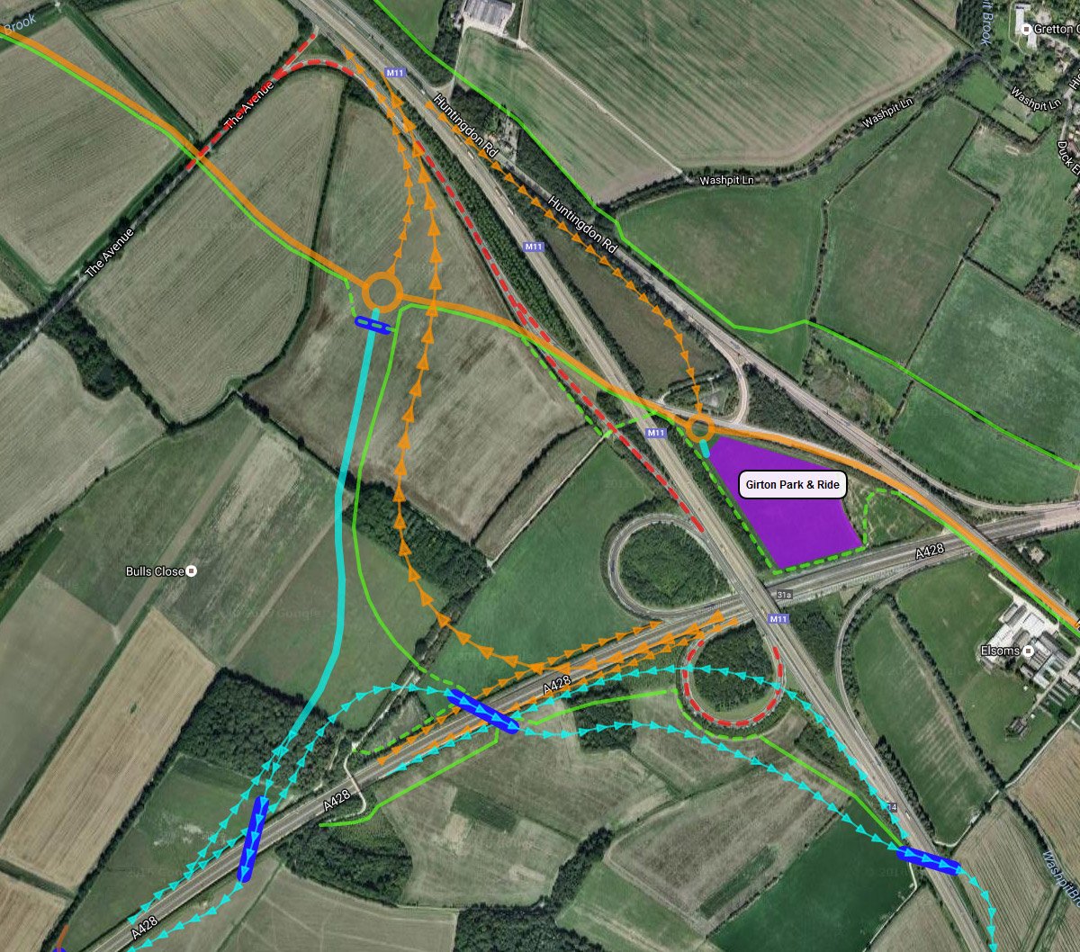
Orange indicates roads to be built and red dashes mark roads to be closed as part of the A14 Improvement Scheme, now underway. Cyan indicates additional roads proposed by Smarter Cambridge Transport. Green indicates cycle/bridleways (existing or to be created as part of the A14 Improvement Scheme), with dashed sections being amendments that we’re proposing. Dark blue indicates a new bridge. The brown line indicates where a new farm access road and bridge might be needed.
Design notes
- The roundabouts on the A1307 (Huntingdon Rd) either side of the M11 should employ elements of ‘turbo’ design to maximise throughput and safety.
- The eastern roundabout, connecting to the Park & Ride site, should integrate the bus stops so as to minimise bus journey times.
- The bus station for the Girton P&R should be designed into the roundabout to minimise bus turnaround time.
- We have shown the cycleway using the existing M11 underpass, officially a bridleway (rather than following the A1307 under the M11, as planned by Highways England).
- The proposed P&R site is 3 hectares, which compares with 4 hectares for the existing Madingley Rd site. The site should be designed to be multi-level, enabling future expansion as demand grows. A compact, multi-level design minimises the land take and environmental impact (including rainwater run-off), and reduces the distance people must walk from their car to the bus station.
All-ways junction
There is a strong case for making this an all-ways junction. The lack of a connection between the A14 east and the A1307 (Huntingdon Rd) means that traffic heading for north-west Cambridge must leave the A14 at the Histon interchange and travel along Histon Rd and via the congested Victoria Rd junction, or rat-run via Windsor Rd and Oxford Rd. There are a few ways in which an all-ways junction might be achieved, one of which we have sketched here:
A14 Improvement Scheme
Highways England is going ahead with a major upgrade to the A14 between Cambridge and Huntingdon. It concluded a public consultation in 2014. The plans have been examined by the Planning Inspectorate and the Secretary of State gave his consent to the Development Consent Order. Construction is expected to finish in 2020.
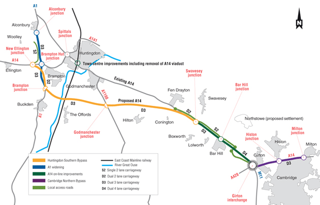
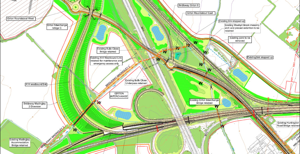
The Girton Interchange is the junction between the M11, A14, A428, and A1307 (Huntingdon Road) just west of Girton village. The current confusing and dangerous design stems from a decision in the late 80s to link the old east-west A45 with the A604 to create the A14.
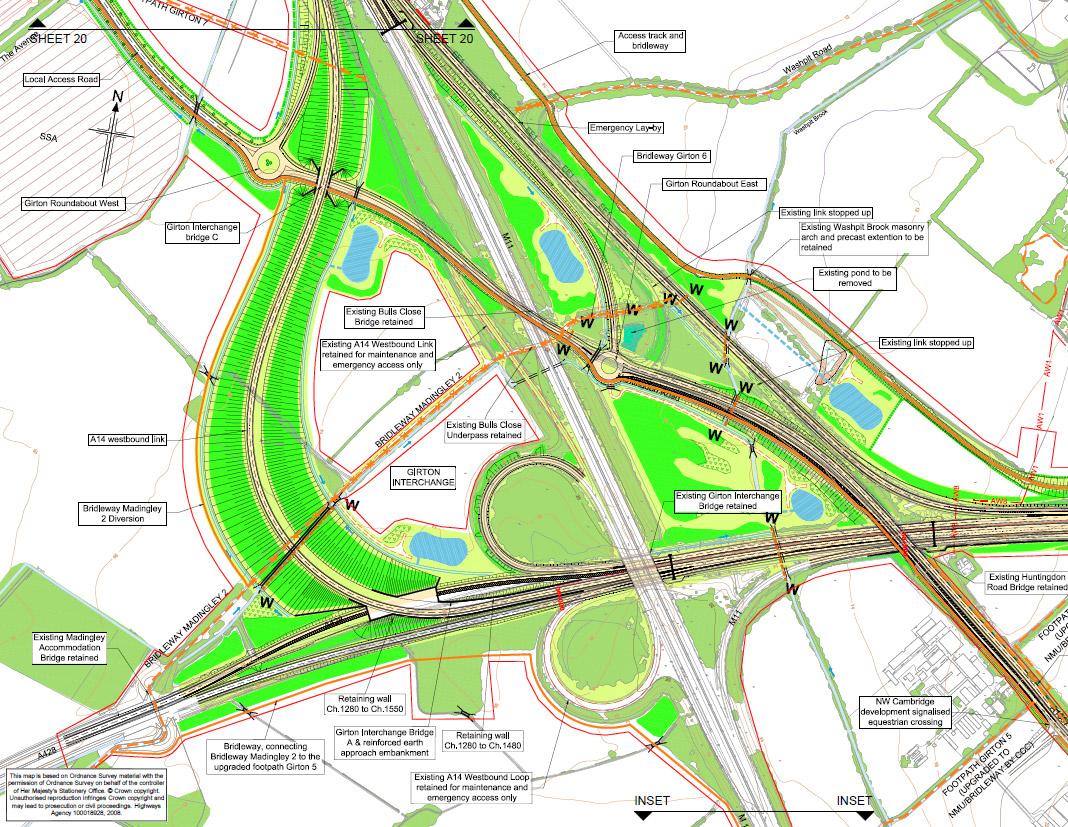
The principal improvements Highways England will make to the Girton Interchange are:
- The tight loop in the A14 westbound is replaced by a gentle curve.
- A new local access road connects Huntingdon Rd to Fen Drayton (and provides a new access to the crematorium).
- Access to Huntingdon Road from the A14 west is via a new roundabout on what will become the local access road.
The principal concerns are:
- It adds no new connections (in fact it removes a connection from the M11), even though it is acknowledged by the County Council and City Deal Board that a high capacity connection between the A428 and the M11 is essential for the viability of planned developments at Cambourne West, Bourn Airfield and St Neots; and also for the realisation of the planned Oxford–Cambridge Expressway.
- Access to the M11 from the A428 will continue to be via the A1303 (Madingley Road), which is already severely congested.
- Access to the A14 east from Huntingdon Road or from the North West Cambridge development will be via a 5.5 mile detour to Junction 29 (Bar Hill) and back (as the Oakington Road junction is to be closed) or, as now, via congested city roads (either Histon Road to Junction 32, or Victoria Avenue and Milton Road to Junction 33).
- The effectiveness of a park-and-ride site at this location will depend on good connections, for cars and buses.
- Whilst addressing the safety concern over the tight loop that currently carries A14 westbound traffic, the safety of the similarly tight loop joining the M11 to the A14 eastbound is not addressed.
- Building a massive embankment and flyover to carry the A14 westbound lanes is unnecessarily expensive.
- Construction will have a huge environmental impact, including obliterating 2 hectares (5 acres) of woodland.
- Elevating the carriageway will amplify traffic noise for residents of Girton, Madingley, Dry Drayton and north-west Cambridge.
Possible future additions proposed by Highways England
In response to representations by Coton Parish Council, Highways England put forward a possible future layout that provides some additional connections (see pages 21–22 of Report 5: Design and Engineering standards). This addresses only objections 1 and 2 above.
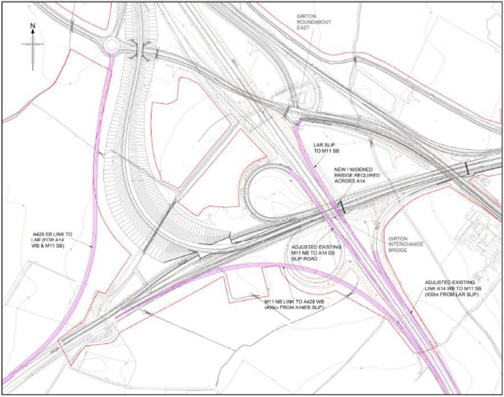
Another option considered by Highways England is to build a new link road from the A428 at the Madingley Mulch roundabout to the M11 at the Barton Interchange (see page 25 of Report 5: Design and Engineering standards). This would meet very serious objections on environmental grounds, and would not provide access to a Park & Ride site at the Girton Interchange. This would entail building a P&R at the Madingley Mulch roundabout, even though the Girton Interchange would be a better location, serving more people and using land that is less environmentally sensitive.
Comparison of connectivity
Significance of cell colours
- Red: detour required to make the connection
- Orange: dangerous or congested connection
- Yellow: sub-optimal connection for a trunk road
- Green: good connection
- A1307 new:
Roads & junctions
- A1307 city: Huntingdon Road
- A1307 new: new local access road to Oakington Road
- Jn 29: Bar Hill interchange (8.8km / 5.5mi detour from Girton Interchange)
- Jn 30: Oakington Rd interchange (to be removed)
- Jn 32: Histon interchange (5.6km / 3.5mi detour from Girton Interchange)
Ease of access to a Park & Ride at the Girton Interchange can be judged from the ease of access to and from the A1307.
Current connections
| FromTo | A14 west | A14 east | M11 | A428 | A1307 |
|---|---|---|---|---|---|
| A14 west | via A1307 | via Jn 32 | |||
| A14 east | via loop | via loop & Jn 30 | via loop & Jn 30 | ||
| M11 | via loop | via Jn 30 | via A1303 | via Jn 30 | |
| A428 | via Madingley | via A1303 | via Jn 32 | via A1303 | |
| A1307 | via Jn 30 | via Jn 30 | via Madingley | via Jn 30 |
Connections post 2020
Note that A14 junction 30 (Oakington Road) will be closed.
| FromTo | A14 west | A14 east | M11 | A428 | A1307 |
|---|---|---|---|---|---|
| A14 west | 2 roundabouts | via Jn 32 | |||
| A14 east | via Jn 29 | via Jn 29 | |||
| M11 | via loop | via Jn 29 | via A1303 | via Jn 29 | |
| A428 | via Madingley | via A1303 | via Jn 32 | via A1303 | |
| A1307 | via Jn 29 | via Jn 29 | via Madingley |
Smarter Cambridge Transport revised proposal
| FromTo | A14 west | A14 east | M11 | A428 | A1307/P&R |
|---|---|---|---|---|---|
| A14 west | 2 roundabouts | 2 roundabouts | |||
| A14 east | via Jn 29 | via Jn 29 | |||
| M11 | via loop | via Jn 29 | via Jn 29 | ||
| A428 | |||||
| A1307/P&R | via Jn 29 | via Jn 29 |
Smarter Cambridge Transport proposed all-ways junction
| FromTo | A14 west | A14 east | M11 | A428 | A1307/P&R |
|---|---|---|---|---|---|
| A14 west | 2 roundabouts | 3 roundabouts | |||
| A14 east | |||||
| M11 | 1 roundabout | ||||
| A428 | |||||
| A1307/P&R |
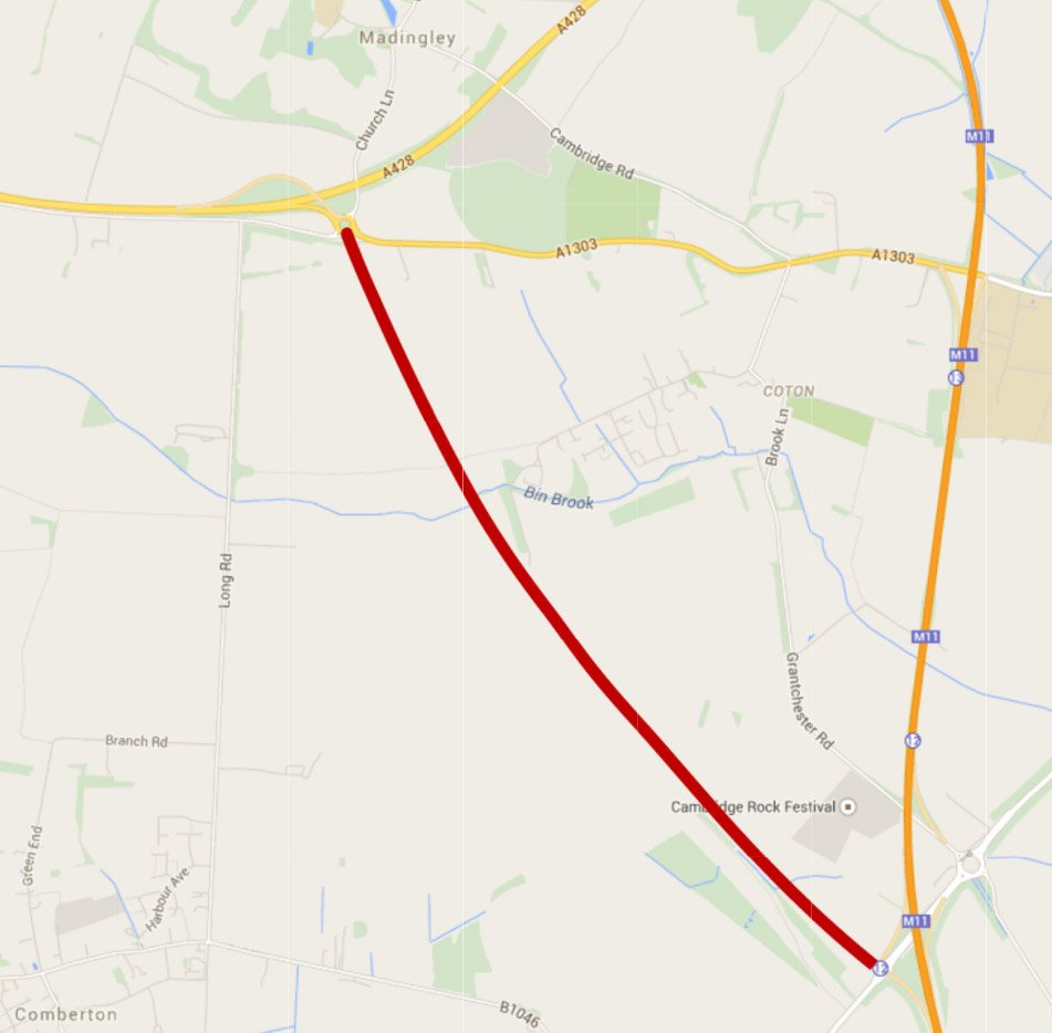
The M11–A1303 junction
Why doesn’t the M11 have slip ramps on the north side of the A1303? On the face of it, this would be a sensible addition that would improve access to north-west Cambridge.
Unfortunately there is a sound safety argument against adding slip ramps here: the distance between this junction and the Girton Interchange is too short for drivers joining and leaving the M11 to switch lanes safely. This is known as the ‘weaving length’, and is illustrated in the diagram below.
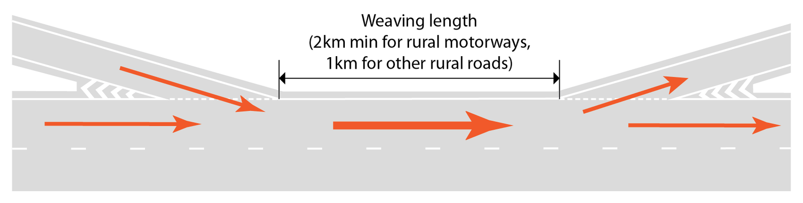
The Design Manual for Roads and Bridges (Volume 6, section 2, part 1, paragraphs 4.34–36) sets a minimum weaving distance of 2km for rural motorways, and 1km for dual carriageways (‘rural all-purpose roads’). On this section of the M11, the distance would be about 770m, which is well below the minimum required.
If you examine other junctions on the M11 and A14, you will see that some are closer together than current minimum standards allow. This contributes to the poor safety record on these roads.
The Smarter Cambridge Transport original proposal
This proposal is no longer viable, but is retained here for reference. We were proposing an alternative to Highways England’s design for the Girton Interchange which would have:
- Created an all-ways junction, shortening journey times.
- Reduced pressure on local roads, in particular the A1303 (Madingley Road).
- Reduced likely congestion at the A14 Bar Hill junction 29.
- Significantly lowered the cost of construction and environmental impact by avoiding building a massive embankment.
- Have had lower noise impact by not elevating the new A14 westbound link.
- Allowed future widening of the A14 westbound link (should this become necessary) without requiring major new groundworks.
- Been less disruptive to the A428 during construction.
We believe that creating an all-ways junction should have been a top priority for the County Council and City Deal, as the benefits for the local economy and labour mobility are readily apparent. We called on the City Deal to push for and, if necessary, commission a design for the Girton Interchange that provides an all-ways connection, with good cycling connections and minimal environmental impact.
You can examine our own attempt at a conceptual design (which should not be taken to be geographically or technically precise). The key features, when compared with Highways England’s planned implementation, are:
- The eastbound inner (slow) lane of the A428 is deflected further away from its current course so that it can be taken over the two westbound lanes of the A14 and (separately) one eastbound and one westbound lane of the A428. This avoids the need to fly the A14 lanes over the westbound lanes of the A428 and minimises disruption during construction.
- The M11 northbound has an exit to the Girton Roundabout West.
- An on-ramp from Girton Roundabout East joins the M11 southbound.
- An entry lane from Girton Roundabout East joins the A14 eastbound, merging with traffic from the A428 and M11 (which merges between the M11 and Huntingdon Rd bridges.
- The M11-A14 westbound exit ramp is retained, but merges with Huntingdon Rd.
- The M11-A14 eastbound loop is rebuilt with a larger radius to improve safety. If the new radius cannot be made large enough to comply with current highways design standards, the alternative would be for traffic to exit to the Girton Roundabout West, then join the A14 eastbound via Girton Roundabout East.
Key
- Small green arrows: single carriageway
- Medium green arrows: dual carriageway
- Large green arrows: triple carriageway
- Thick solid green: two-way single-carriageway
- Thin solid orange: farm tracks, bridle path and cycle paths
- Red dashes: closed road
- Blue block: new park-and-ride site
This proposal received general support, including formal support from Bar Hill Parish Council (at their October 2015 meeting).
Comparison of major structural works
| Highways England proposal | Smarter Cambridge Transport proposal |
|---|---|
|
|
Add comment