
This is the Smarter Cambridge Transport response to the Cambridgeshire & Peterborough Combined Authority Local Transport Plan consultation. More details of the plan can be found here.
A PDF version of the document below can be read here.
Executive summary
The Local Transport Plan (LTP) prioritises economic growth above all else. Economic and population growth are drivers for change, not end goals. The true end goals are social, environmental and public health outcomes – required by law or expressly desired by local communities that live, work and study in Cambridgeshire and Peterborough. Therefore, policies in the LTP need to shape and channel how growth drives change to deliver those outcomes.
The LTP needs to be uncompromising in its commitment to de-carbonise local transport well before 2050, eliminate pollution from transport, and increase social and individual wellbeing. However, many of the LTP policies are about enlarging road capacity. These will increase the volume of motor traffic, and hence carbon and pollution emissions, and undermine efforts to induce modal shift to modes of transport that are more sustainable and accessible to all of society, not just those with use of a car. Policies must therefore channel travel demand into public, shared and active transport, and more efficient movement of freight.
The LTP needs to be more succinct and clearer about the practical (measurable) outcomes it is seeking to achieve. It should set out how effects will be measured and monitored to ensure they align with intended outcomes. The LTP needs to be kept in sync with changing local, regional and national policies, priorities and plans on the environment, housing, business and transport. This requires a defined process for adjusting and supplementing policies as circumstances and evidence evolve.
The consultation on this draft Local Transport Plan needs to reach much deeper into the communities, businesses, schools and other organisations that will be affected for years to come by what is included or omitted from the plan. The structure, content and presentation of the LTP needs to be more conducive to engagement and public debate that will materially influence the content of the plan.
We have provided examples of additional transport interventions for consideration, mainly focused on the Greater Cambridge region. There are many more ideas that local communities and businesses would suggest if consulted in the right way.
Commentary
Consultation process
The presentation of the consultation document is not in the spirit of open public engagement. It has been poorly publicised: very few people – including councillors – know anything about the new Local Transport Plan, why it is important, or that they have an opportunity to shape it. The consultation documentation is mostly about abstract principles and history, with relatively little about practical outcomes. Yet it is the latter that people are most willing and able to engage with.
We are not aware of any attempt to engage specifically with women, yet there is growing evidence that transport policies do not serve women’s needs well – in terms of supporting multi-destination trips and creating environments that feel safe. Similarly, the specific interests of school-age, elderly, disabled, isolated, and other “hard to reach” groups do not appear to have been sought. Without their input, how can anyone be sure that the policies will deliver “a sustainable transport network that is affordable and accessible for all” (Policy 6)?
The LTP document is constructed as a statement of intent, with no questions or choices for the public to consider; no invitation to propose new schemes for consideration; and no forum in which the proposals, or amendments or additions suggested by interested parties, may be discussed and debated openly. Not only does this approach reinforce cynicism amongst the public about how much influence they can have through consultation, it fails to tap into the wisdom and detailed local knowledge of Cambridgeshire and Peterborough’s citizens and employers. There are many small-scale changes to infrastructure, services, funding and communication around transport that could deliver significant benefits quickly, cheaply and with relatively little controversy. Few of these feature in the LTP.
Given the great importance the LTP has in shaping how people live and work in the region, we urge the Combined Authority to invest in a genuine engagement exercise, managed by a team with local connections and professional expertise in community engagement. The presentation of the plan should be filterable by theme and geographical area to allow people to focus on what interests them. Schemes should be presented on a map that allows people to comment and discuss ideas publicly. A Citizens’ Assembly should be considered as a way for the community to deliberate on difficult and complex choices to assist politicians in making decisions.
General observations
There is really only one “big idea” in this plan: the Cambridgeshire Autonomous Metro. There are huge uncertainties about its viability, financially and technically, yet almost every objective of the strategy – at least for Greater Cambridge – is dependent on its timely delivery and reliable operation. To proceed without a contingency plan would be reckless.
The LTP is packed with vague assertions that lack detail, targets, milestones and evidence (“we want”, “we believe”, “do its part”, “promotes”, “protects and enhances”, “consideration will be given”, “minimises the impact”, “puts people first”, “sustainable”, “accessible”, “world-class”). These are no more than mood music and should not feature in the main body of a strategy document.
Much of the text appears to be an account of what has already been delivered. This should be moved into an appendix to the LTP, so that the main body of the plan is concise and forward-looking.
The projects set out in the High Level Delivery Plan are an incoherent and incomplete jumble of schemes. Local communities have not had an opportunity to consider whether these projects are appropriate or if they have alternative suggestions. The environmental sustainability and social benefits of most of the projects are simply asserted without evidence, even though increased road capacity is strongly correlated with increased emissions of CO2 and toxic pollutants. There is no discussion of the wider and cumulative social and environmental impacts of projects, which are essential features of transport interventions. It is essential that schemes are justified, appraised/evaluated and monitored together, as complementary contributors to achieving one or more aims of the LTP.
Every aim in the LTP should be accompanied by:
- quantified outcomes (metrics)
- regular milestones and programmed reviews to track progress and amend plans
- identification of local government bodies, departments or partner agencies responsible for delivery
- a named individual with overall executive responsibility and accountability
- the budget and funding sources for delivery
- incentives for success
- penalties for failure
Metrics should be published at least annually, if not quarterly, for all relevant outcomes, including:
- carbon emissions
- population exposure to pollution
- public health measures connected to exposure to pollution
- public health measures related to car-based lifestyles
- efficiency of infrastructure usage, measured as movements of people (not vehicles) and freight (peak periods, daily, weekly and annually)
- scheme costs (planning & preparation, capital, operating, maintenance and repairs) presented transparently
Comments on Section 1. Transport Vision 2050
1.37 “doubling the size of the local economy over 25 years”
Here and elsewhere in the LTP, the specific commitment and time frame in the devolution deal should be stated: “GVA will increase from £22bn to over £40bn” in 2041.
The statement of ambition omits reference to:
- de-carbonising transport and lifestyles (Policy 10);
- eliminating toxic pollutants from transport (Policy 8);
- making all modes of transport safe – Vision Zero (Policy 5);
- improving public health through greater participation in active transport (Policy 7);
- reducing individual isolation by ensuring everyone has access to jobs and essential amenities by public, shared and active transport (Policy 6);
- designing transport infrastructure to protect and enhance the natural and built environment (Policy 9);
- making transport systems resilient to climate change (Policy 4).
1.38 The referenced “new garden villages” and “Spatial Framework” are not yet in the public domain, yet have a decisive bearing on the LTP. The LTP will need to be reviewed and updated when those are published.
There is a growing consensus in planning and urban design that the most sustainable form of development is dense, of a scale for many amenities to be within walking or cycling distance, and to be well-connected by public transport to centres of employment and amenities not provided locally. Even with a rail or CAM station, a garden village of fewer than 10,000 homes is unlikely achieve this. The spatial strategy should therefore focus on new towns and urban extensions.
1.40 “We are committed to rigorous prioritisation based on business cases which assess the impact of the projects on future growth.”
This is a one-dimensional test. Growth, and transport schemes supporting growth, must deliver social, environmental and public health outcomes required by law and expressly desired by people who live, work and study in Cambridgeshire and Peterborough.
1.45, 1.47 Economic growth is not an end goal: social, environmental and public health outcomes are primary. Economic growth must enable, not hinder, their realisation.
1.48 We fully support this vision statement.
1.49 We support this vision statement, but the commitments on air quality and carbon emissions need to be quantified to be at least as ambitious as the prevailing national legal targets (set out currently in the Climate Change Act 2008, as amended in 2019: “It is the duty of the Secretary of State to ensure that the net UK carbon account for the year 2050 is at least 100% lower than the 1990 baseline.”)
Comments on Section 2. Our Strategy
2.9 “Investment in world-class walking and cycling facilities … encouraging people to walk or cycle rather than drive for shorter journeys.”
The context and scope for modal shift from driving to walking and cycling is illustrated in the National Travel Survey, which reveals that, nationally, most trips by car are under five miles, and 25% are under two miles (see Figure 1). Incentivising modal shift away from driving for short trips requires policies that fully embrace the urban transport hierarchy (see 2.17 below).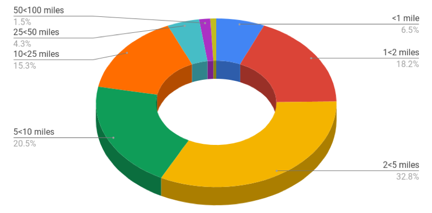
Figure 1: Breakdown of car trips by distance. Source: National Travel Survey 2018
2.12 “Growth will be inclusive, truly sustainable and spread evenly across the entirety of the area, creating a place where all members of our community contribute to, and benefit from, our area’s growth and success.”
This is a vision statement, not a strategy.
2.17 The “high-level user hierarchy” is an important policy guide for urban and residential roads (which includes village high streets). We offer a refinement of this in Figure 2, which expands on ‘specialist service vehicles.’ It also adds ‘verges’ as an essential component of the highway. Thirdly, it includes the actions required to realise and sustain the urban transport hierarchy.
The green space beyond the asphalt (loosely referred to here as ‘verges’) can serve many functions:
- sustainable drainage reduces flooding from heavy rainfall;
- trees provide shelter from rain;
- trees provide shade from sun, significantly reducing ground level temperatures in the summer;
- trees and shrubs create a pollution and noise barrier;
- locally appropriate vegetation provides a habitat for healthy biodiversity;
- attractive landscape significantly increases people’s willingness to walk or cycle.
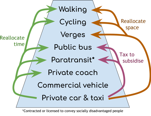
Figure 2: The urban transport hierarchy and how policies must act to make it a reality
Comments on Section 3. Local Strategies
3.63 “Park & Ride sites will continue to provide sustainable options for those who do not have a feasible alternative to the car, but will be better integrated into surrounding local transport networks, acting as travel hubs with high-quality interchange between CAM and local bus and demand-responsive services, together with the walking and cycling network.”
Park & Ride is nearing the end of its useful life. The total number of parking spaces available in 2019 is 7,017. At least another 7,500 are planned as part of Greater Cambridge Partnership schemes. That additional capacity equates to less than 8% of all motor traffic currently entering Cambridge.
The Greater Cambridge Partnership’s goal of reducing motor traffic by 10–15% on 2011 levels equates to a reduction of around 19,000 vehicles. Add forecast growth in travel demand to the Cambridge Biomedical Campus of 26,000 new weekday trips by 2031, that is equivalent to at least 17,500 car trips (assuming a higher than average occupancy rate of 1.5 people per vehicle). An additional 7,500 Park & Ride parking spaces will capture just 20% of just those two sources of increased travel demand. The expected 40% increase in population in Cambridge (up around 40,000) and South Cambridgeshire (up around 80,000) by 2031, will further increase travel demand throughout the region.
Park & Ride has been shown to abstract patronage from local bus and train services, and therefore undermines what should be the primary objective, which is to provide convenient and attractive transport services from close to people’s homes, not just from city edges.
3.66 “30,000 additional journeys by 2031” is ambiguous as to whether a “journey” is a one-way trip (to or from the campus) or a return trip, and does not specify that the time period is a weekday. The Cambridge Biomedical Campus Transport Needs Review Part 2 (Atkins, 2018) forecast an increase in trips entering the campus from 41,387 in 2017 to 67,500 in 2031. That is 26,113 additional trips in, and the same number out, each weekday.
3.67 “Demand management” is a generic term for any measure that suppresses demand to travel. Removing parking spaces, increasing parking charges, restricting access, or charging for access all have this effect. The specific meaning(s) intended here need to be made explicit.
3.68–69 “Targeted highway improvements will therefore provide additional capacity” is as wrong now as it was in 1955, when Lewis Mumford likened this approach to loosening one’s belt as a cure for obesity. Countless studies have confirmed the “induced demand” effect, where increased capacity incentives people to travel further for work, shopping and leisure; to drive rather than take alternative transport modes; and to drive at peak times rather than off-peak.
Congestion is displaced to the next weakest point in the road network unless an entire route is upgraded, end to end. For instance, dualling the A10 between Ely and the A14 will increase congestion on Milton Rd and the A14. Induced demand causes congestion to build up again on the “upgraded” link, with delays returning to pre-upgrade levels typically within five years. Furthermore, faster journey times by private car reduces demand for public transport, making bus routes less economically viable, precipitating a downward spiral in service hours and frequency, and hence patronage.
The highest priorities for “targeted highway improvements” should be to reduce journey times and variability for buses and coaches, and to reduce danger (real and perceived) for people walking and cycling.
3.69 The Oxford–Cambridge Expressway and East West Rail both aim “to improve strategic connectivity and key freight linkages with the rest of the country.” The difference is that the rail option can do this with a much smaller carbon footprint per passenger-mile and per tonne-mile. Therefore, the LTP should support East West Rail and not the Expressway (west of the M1).
3.74 “We will therefore support the Greater Cambridge Partnership in the delivery of a new segregated public transport corridor to Cambridge …”
There is already a segregated public transport corridor from Waterbeach to Cambridge, London, Stansted Airport and many other destinations. No justification is provided here for why a busway is required as well, when it will struggle to compete with the much faster rail service.
If Cambridge North station were served by a fast, frequent bus service to the Science Park and nearby business parks, Cambridge Regional College, Orchard Park, Darwin Green, Eddington and West Cambridge, and the cost to use the bus were a small premium on the rail fare, this would be an attractive and far more cost-effective transport solution than building a new busway.
3.75 “Dualling of the A10, combined with upgrades to Milton Interchange, will provide additional highway capacity …”
As discussed under 3.68, this upgrade will further stress Milton Rd, the A14, A428 and M11. It will contribute little, if any, economic benefit in the long run, and will undermine efforts to incentivise modal shift to active and public transport.
Upgrades to the A10 should focus on increasing safety for all road users and reducing delays to buses. Dangerous junctions should be remodelled. Where there are frequent conflicts with slow-moving agricultural vehicles, then passing lanes, new road links or bridges should be considered. A protected cycleway should be built to connect north Cambridge, Milton, Waterbeach, Stretham, Little Thetford and Ely.
From Milton Park & Ride, a bus-and-cycle route could be constructed to Orchard Park via the ‘spare’ underpass behind the Cambridge Regional College, connecting to King’s Hedges Rd and the Guided Busway. This would provide an alternative route at peak times for Park & Ride and express bus services, avoiding five sets of traffic lights and congestion around the A14 interchange.
3.150 “Doubling of the track between Ely, Soham and Newmarket, together with rebuilding the ‘western curve’ at Newmarket, is currently being explored for the longer term …”
There is no justification given for why these upgrades should be “longer term”, when there is huge potential demand now to travel from Newmarket, Bury St Edmunds and Soham to Cambridge. Newmarket has a similar population to Ely, yet footfall at Newmarket station[1] is just 16% of that at Ely[2].
Comments on Section 4. Our Policies
Policy 1. Support new housing and development to accommodate a growing population and workforce, and address housing affordability issues
“Early engagement with developers” makes no reference to outcomes. Transport requirements need to be defined before a developer arrives on the scene. The developer has to forecast what the cost of transport infrastructure will be when they are negotiating a land purchase option price, long before local authority planning staff get involved.
Therefore, it is essential that clear design and technical standards are specified in documentation available to all landowners and developers. This will ensure that a realistic delivery cost is factored into developers’ calculations. More importantly, it means that planning and highway authorities can enforce those design and technical standards. A viability assessment cannot annul a developer’s obligation if it was (or should have been) known in advance of purchasing the land.
Policy 2. Connect all new and existing communities sustainably so residents can easily access a good job within 30 minutes, spreading the region’s prosperity
“Connect all new and existing communities sustainably so residents can easily access a good job within 30 minutes, spreading the region’s prosperity.”
There is no objective definition of a “good job”, so this is meaningless. Rather, residents should have access to a variety of jobs.
The “within 30 minutes” should be qualified with “by a sustainable transport mode”. Otherwise it could be satisfied by building multi-lane highways all across the county, which would be environmentally, ecologically and socially damaging, and at odds with other policies, including Policy 10 on greenhouse gas emissions.
Since commuting accounts for only about 15% of all trips (based on the National Travel Survey), and the LTP is about giving people sustainable transport alternatives not only for commuting, the “within 30 minutes” metric should cover all major destinations, including primary and secondary schools, shops providing monthly essentials, the local GP surgery, and a variety of indoor and outdoor leisure activities.
Policy 3. Ensure all of our region’s businesses and tourist attractions are connected sustainably to our main transport hubs, ports and airports
We are supportive of this policy with a broad definition of ‘sustainably’ (to include at least the environment, natural and built heritage, and quality of life), as long as it is informed by reliable evidence and adequately resourced.
Policy 4. Build a transport network that is resilient and adaptive to human and environmental disruption, improving journey time reliability
“Supporting highway authorities in minimising the whole life costs of the highway.”
This requires higher construction standards for footways and cycleways than is typically specified today.
There is no policy on maintenance of footways or cycleways. There needs to be a dedicated budget and cyclical maintenance programme to ensure that footways and cycleways are not allowed to degrade to the point where they deter people from using them:
- Vegetation needs to be kept in check.
- Cracks, ruts, ridges and tree-root damage need to be repaired promptly.
- Paths need to be gritted in winter.
- Drains need to be kept clear.
Policy 5. Embed a safe systems approach into all planning and transport operations to achieve Vision Zero – zero fatalities or serious injuries
We are very supportive of this policy, as long as it is informed by reliable evidence and adequately resourced.
The central objective of the “safe systems approach” is to “manage our infrastructure, vehicles and speeds to reduce crash energies to levels that can be tolerated by the human body” (Working Together to Build a Safer Road System –British Road Safety Statement).
As speed of impact is the most significant determinant in the survivability of a collision, the LTP should explicitly support local efforts to reduce maximum speeds of motor vehicles, by altering road layouts and junction designs, lowering speed limits and targeting enforcement.
Best practice in highway design is an area of active research, which designers need to keep abreast of – see in particular problems identified with ‘shared space’ (DPTAC position on ‘shared space’).
Policy 6. Promote social inclusion through the provision of a sustainable transport network that is affordable and accessible for all
We are strongly supportive of this policy, as long as it is informed by reliable evidence and adequately resourced. That requires wider and deeper consultation with all communities to ensure that transport infrastructure and services meet the needs of everyone.
Walking and cycling should be mentioned here, as they are the most accessible and appropriate modes of transport for short trips.
“Improving the accessibility of transport infrastructure” is ambiguous: both senses should be included:
- Transport infrastructure should, as far as possible, allow most people to make most trips by a combination of active and public/shared transport.
- Transport infrastructure and services should, as far as possible, be usable by people with impaired mobility, reduced sensory acuity, or neurological and mental health conditions.
Policy 7. Provide ‘healthy streets’ and highquality public realm that puts people first and promotes active lifestyles
We are very supportive of this policy, as long as it is informed by reliable evidence and adequately resourced.
Policy 8. Ensure transport initiatives improve air quality across the region to exceed good practice standards
This policy requires milestones for reductions in pollutants from internal combustion engines (NOx, CO, SO2, volatile organic compounds and particulates), tyre wear (microplastics) and brake assembly wear (ferrous oxides). These should be set at or below legal thresholds and regularly reviewed in the light of contemporary evidence.
This policy should also cover noise and vibration, which have measurable effects on mental health.
Vibrations from HGVs and buses, and from all vehicles running over uneven or poorly-maintained road surfaces can cause costly damage to buildings and underground services (e.g. sewers and water pipes).
Policy 9. Deliver a transport network that protects and enhances our natural, historic and built environments
This policy, if taken literally, would block all new infrastructure. It does however support a desirable strategy of using existing infrastructure more efficiently, e.g. conveying more people by bus rather than single-occupancy cars.
To be meaningful, this policy should be re-phrased in terms of optimising use of existing infrastructure so as to minimise the amount of new infrastructure required; and designing new infrastructure to cause minimal damage to natural and build heritage.
New infrastructure should be designed to avoid, as far as possible, dividing communities or reducing access to community amenities (schools, shops, recreation grounds, etc). It should also avoid interrupting animal habitat corridors and migration paths.
Policy 10. Reduce emissions to as close to zero as possible to minimise the impact of transport and travel on climate change
This policy should be combined with policy 8, as the solutions overlap (e.g. electrifying transport reduces air pollution).
At a minimum, this policy must meet the statutory requirement to reduce greenhouse gas emissions to net zero by 2050. Given the strength of accumulating evidence on the existential threat of climate change, a target date close to 2030 should be adopted.
This policy must also be linked to a policy on energy supply. Any increase in electricity consumption – for transport or any other purpose – must be matched by an increase in output from net-zero-carbon electricity generation.
Modal policies
Policy 11. Walking
The word “direct” should be included, as distance is a significant determinant of whether people choose to walk; also, the words “segregated from motor vehicles and cycles”, as shared spaces are off-putting to many people, including those with sensory and neurological disabilities.
Policy 12. Cycling
The policy detail has been inadvertently copy-and-pasted from Policy 11.
The words, “protected, i.e. physically separated from motor traffic, car dooring zones, footways and concealed driveway entrances,” should be included as these design elements reduce deaths and injuries, increase female participation in cycling, and give parents confidence to let younger children cycle.
Increasing provision of cycle parking provision in step with increasing participation needs to be an explicit policy objective. Spatial and transport planning policies need to be aligned on the standards required for the quantity, security, accessibility and types of provision (for bicycles, tricycles, cargo bikes, bikes with trailers and hand cycles).
Policy 13. Delivering a seamless public transport system
“Exploring” is not a policy objective. There should be a clear statement of minimum standards for information provision, inter-operator and inter-modal ticketing, quality of waiting facilities (appropriate to the volume of usage and maximum interchange wait times), and minimum terms of carriage (e.g. requiring operators to provide alternative transport when cancellations or delays exceed a reasonable threshold).
Park & Ride (a large car park by a bus or rail station) has a very specific and limited role in the future of an integrated transport network in intercepting longer-distance traffic close to a destination. This is not an appropriate strategy for trips originating in the local (“journey-to-work”) area. Local trips require a distributed network of small, multi-modal travel hubs (see Travel hubs below).
Policy 14. Rural transport services
This policy should make clear that there needs to be a hierarchy of bus services:
- rapid and frequent (‘express’) services between travel hubs and major destinations;
- feeder services connecting a wider area to travel hubs;
- local services connecting a wider area to major destinations (which communities may prefer until travel hubs are well-established with reliable connections and high-quality waiting facilities);
- demand-responsive, community and other shared minibus/minicab services.
The word “stakeholders” should be replaced by something along the lines of “employers, schools, local and regional health service providers, retailers, and other organisations whose activities depend on good transport connections.”
Policy 15. Improving public transport in our cities
“improve service quality, reliability and frequency”
This would be better expanded along the lines of, “extend hours of service; increase frequencies; reduce the number of cancellations; reduce journey time variability; increase provision in line with demand to avoid overcrowding and prolonged standing; minimise dwell times; streamline ticketing; provide clear information about routes and fares at bus stops and on buses; update operators’ conditions of carriage to be more favourable to passengers; include WiFi and USB charging on buses and at bus shelters; provide audio and visual announcements on buses in advance of stops; and provide accurate real-time service information.”
“Deliver transformational mass transit within our cities”
For Cambridge this presumably refers to CAM? But for Peterborough, what can be meant?
Any policy on introducing a new mode of transport to replace bus services should be underpinned by a clear analysis of need, demonstrating either that the volume of future demand cannot be met by bus services, or that latent demand can only be satisfied by a new mode. Comparison with bus services must consider what buses and services could be like in the future, using all-electric buses, intuitive routes, real-time journey planning, and simplified ticketing.
In other words, it must be the additional patronage attributable to unique qualities of the mass transit service (bus rapid transit or light rail) that justifies the investment in new infrastructure and vehicles.
Policy 16. Travelling by coach
“Integrating coach services with wider public transport and highway networks”
“wider public transport” would be better expanded as “rail and local bus services”. The “and highways networks” can be omitted as it adds nothing to the policy (coaches have largely unrestricted access to the highway network).
Policy 17. Travelling by train
The policy commitments could be stronger and more specific, along the lines suggested for bus services in Policy 15 (above).
Examples of “improvements to our rail stations” include provision of cycle parking and bus stops close to the station entrance, direct access on foot from all directions (i.e. avoiding long detours via bridges or level crossings), step-free access to all platforms, toilets, shelters, ticket machines on all platforms, and luggage storage lockers.
Policy 18. The local road network
This policy should explain how responsibility and funding for the Key Road Network differs from the local and strategic road networks, and why this is important.
Policy 19. Parking
“Managing parking demand” is ambiguous, as it could mean increasing (or redistributing) provision to match demand. The objective should be to reduce demand by providing attractive alternatives and reducing supply, allowing land currently allocated to car storage to be used for more sustainable purposes.
Policy 20. Making long-distance by car
As stated, this is a carte blanche for limitless road building, which is not intended nor compatible with other policies, including Policy 10 on carbon emissions.
The policy should make clear that the primary strategy for reducing congestion is to enable and encourage more efficient use of the existing road network by enabling and encouraging modal shift from single-occupancy cars to buses, coach and ride-sharing; and consolidation of freight movements.
Linking with Policy 17, the secondary strategy is to enhance access and connectivity on the rail network to enable modal shift from car to rail for long-distance passenger trips, and HGVs to rail for long-distance freight movements.
Additional schemes for inclusion
Travel hubs
Travel hubs are multi-modal transport interchanges, designed to facilitate access to public transport for trips starting and ending within the local area, e.g. from Burwell to the Cambridge Biomedical Campus. They are distinct from bus park-and-rides, which are primarily designed to facilitate interchanging between private car and bus at the edge of a city.
Park-and-rides have served a useful role in the past, but in future their role should be limited to intercepting longer-distance trips that cannot be served well by public transport from closer to home (or other origin). For this reason, park-and-rides should be located close to strategic highways (such as the M11, A14 and A1). Parking charges should be set at a level that incentivises local people to use public transport from closer to home rather than driving to a park-and-ride.
Travel hubs are distinguished in being located in or very close to a village, typically one with a secondary college, GP surgery or other destination. They facilitate interchanging between train and/or rapid/express bus services, and a variety of local transport connections. Those will always include safe and attractive footways and cycleways, and a pick-up/drop-off area. They will typically also include local, feeder, demand-responsive or community bus services. Any parking provision is at a scale determined by local needs and ambitions (which may include a desire to provide space for local markets and mobile services).
CAM stations are correctly described in the LTP as travel hubs. It is just as important that villages not on the CAM network also have travel hubs to facilitate access to train or express (rapid and frequent) bus services to Cambridge and market towns in the region. Residents and potential hub users should be consulted on the location and facilities for their travel hub:
- Babraham
- Barton
- Burwell
- Cambourne
- Comberton
- Cottenham
- Fenstanton
- Fulbourn Hospital (potential rail station)
- Harston
- Haslingfield
- Linton
- Little Shelford (potential rail station)
- Six Mile Bottom (potential rail station)
- Trumpington
The following locations already have a rail or bus station (or the future location is already determined), so residents and station users should be consulted on the facilities for their travel hub:
- Dullingham
- Foxton
- Longstanton
- Meldreth
- Shepreth
- Soham
- St Ives
- Waterbeach (including the new town extension)
- Whittlesford Parkway (building on the masterplan currently being developed)
Strategic road network
The M11, A14 and A11 form a triangle around Cambridge. This has the potential to be a continuously-dualled outer orbital route if connections were added between the A11 and the M11 north, and between the A11 and the A14 west. It would then be possible for traffic to bypass a closure of any one side of the triangle without using local roads.
Road delays owing to roadworks, collisions and other incidents reduce the productivity of haulage and other businesses that use the strategic road network. Diverting this traffic onto local roads causes severe congestion and reduces the productivity of local businesses. Creating greater resilience in the network should be a higher priority than creating greater capacity, given the unwanted induced demand effect of the latter.
A428–M11 junction (Girton Interchange)
Even after the A14 Improvement Scheme is completed, connections at the Girton Interchange will be limited. Traffic moving between the A428 and M11 will still have to use a congested single-carriage local road (A1303). Cambridge city centre is not the only destination: traffic arriving on the A428 from Cambourne, St Neots, Bedford, Milton Keynes, Oxford, etc is also aiming for the Cambridge Biomedical Campus, the science parks south of Cambridge (Wellcome Genome Campus, Babraham Research Campus, Granta Park, Chesterford Research Park), and Stansted Airport.
The Oxford-Cambridge corridor needs to connect seamlessly with the London-Stansted-Cambridge corridor, which requires the Girton Interchange to be reconfigured with this connection.
A connection between the A428 and A1307 is also required in order to connect with a Park & Ride and coach station at the Girton Interchange (see below).
A11–M11 north junction (M11 Jn 9)
The addition of this connection would relieve the A505 and A1301, and facilitate from the north to Hinxton, Wellcome Genome Campus, Great Chesterford, Saffron Walden, Wendens Ambo, Newport, and other villages.
A11–A14 west junction (A14 Jn 36)
The addition of this connection would reduce traffic on Wilbraham Rd and through the Wilbrahams.
In an incident closes the A14 between the M11 and A11 junctions, traffic could be diverted via the M11 and A11 without using local roads. Similarly, if an incident closes the M11 between the A14 and A11 junctions, traffic could be diverted via the A14 and A11 without using local roads.

Figure 3: Three junctions on the strategic road network lacking connections that would facilitiate access to and from villages and employment sites, and resilience in the strategic road network
Girton Interchange transport hub
The Girton Interchange, where the A14, A428 and M11 meet, is a perfect location for a multimodal transport hub. It is the most suitable location for:
- a large Park & Ride, designed to serve traffic from beyond the local transport network;
- a coach station for both north-south and east-west services, enabling easy interconnections;
- local feeder bus services;
- shared and private transport pick-up and drop-off;
- a mass transit service into Cambridge city centre, Cambridge railway station, and Cambridge Biomedical Campus, the three largest destinations in the city.
A possible design for an all-ways junction is illustrated in Figure 4.
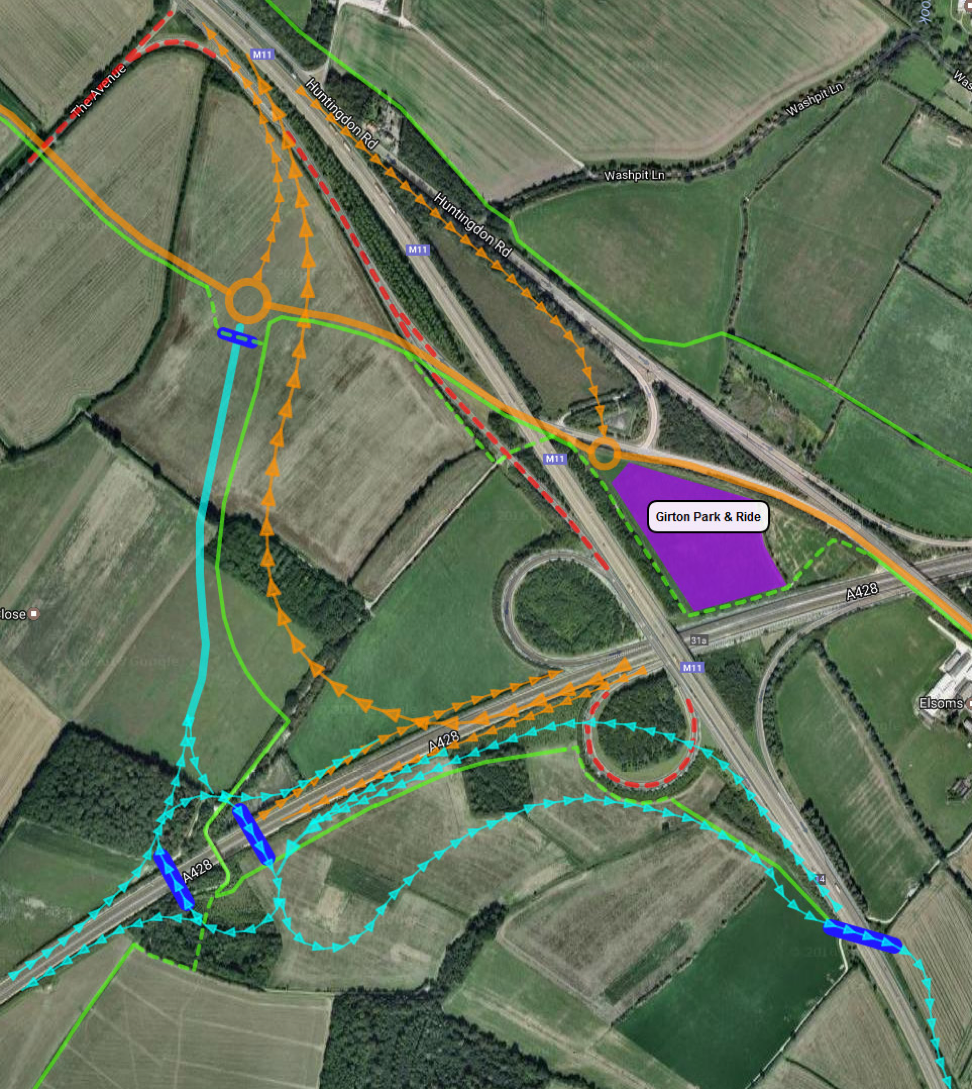
Figure 4: Possible reconfiguration of the Girton Interchange to connect the M11, A428, A14 and A1307. Orange lines are alignments currently being constructed as part of the A14 Improvement Scheme.
Smart traffic signals
An integrated Urban Traffic Management and Control System in the region’s cities and large towns would reduce congestion and pollution, and improve the road network’s resilience to roadworks, breakdowns, collisions and seasonal variations in demand. Although this is not a long-term solution to congestion (the additional capacity released would soon fill up again), it would buy time to implement other schemes.
Inbound Flow Control
In urban and residential areas, highway space is most needed for walking, cycling and green space (see commentary on paragraph 2.17 above). Adding bus lanes compromises provision for people walking and cycling, by making the road more difficult to cross, and reducing the width of foot and cycle paths and/or the separation between motor traffic and people walking and cycling.
A better strategy for improving bus priority is to provide a bus lane at the edge of the city alongside one or two general traffic lanes where, during the morning peak, traffic can be queued and released at a rate that allows traffic, including buses, to flow freely into the city centre. The delay to general traffic is small, but the benefit to buses is relatively large. This creates a significant and visible incentive to use the bus rather than drive.
Railway stations
A station is needed to serve Fulbourn, Cherry Hinton and Teversham. (This is mentioned in the current Local Transport Plan but omitted from the new draft.) A possible location is at Fulbourn Hospital, where Fulbourn Old Drift crossed the railway line. Another option would be to re-route the mainline railway further to the north, through the Cambridge airport site. The existing railway alignment could then be converted to light rail, with more stops.
A new station at Six Mile Bottom, accessed from the A11, could serve as a parkway station.
A new station at Little Shelford could provide access to the King’s Cross/Thameslink line from the Shelfords and Hauxton.
A new station at Little Thetford could improve access to the railway from Little Thetford, Barham and Stretham (with a direct cycleway).
Kennett station could be upgraded to be a railhead for Mildenhall and a future development on the airbase. A light rail or busway connection to Mildenhall could be a better investment than a CAM busway all the way to Cambridge.
Haverhill railway
The Greater Cambridge Partnership is currently consulting on a busway between the Biomedical Campus and the A11 at the 1307 interchange. A more ambitious and future-proof plan is needed to provide a public transport connection between Haverhill and Cambridge, linking to villages and employment sites in between. The draft viability study of reinstating a heavy rail line to Haverhill, produced by WSP, determined an initial benefit-to-cost ratio of 0.99. This would normally be sufficient to warrant further research.
A mainline railway would provide faster access, with fewer interchanges, to more destinations, including Peterborough, London and Stansted Airport. The four-tracking already planned between the junction north of Great Shelford would be able to carry additional trains from Haverhill, via a junction south of Stapleford. This would be far preferable the GCP plan to build a new road between the railway line and Nine Wells nature reserve.
Harston bypass
There are two problems with the current route of the A10 between Foxton and the M11: the increasing number of train services between Cambridge and London (and, potentially in future, Bedford) interrupts traffic flows for extended periods, leading to congestion and high levels of pollution around the level crossing.
The volume of traffic flowing or queuing through Harston is highly detrimental to life in the village, with residents exposed to high levels of pollution, noise and road danger.
A potential alternative route for the A10 is to follow along the south side of the railway line to London Rd, where there is a bridge over the railway (see Figure 5). This would avoid the level crossing at Foxton and divert traffic away from most of Harston.
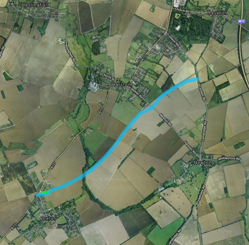
Figure 5: Potential A10 Harston bypass route for consultation
Cycle parking provision
Modal shift from driving to cycling requires secure, convenient cycle parking everywhere. The number of cycle parking spaces available needs to grow ahead of the rate at which modal shift is desired. Fly-parking of cycles on pavements is undesirable because it obstructs people walking, in wheelchairs and mobility scooters, or pushing children’s buggies.
Provision at scale in city and town centres and at major railway stations will require dedicated, in some cases multi-storey, cycle parks. These need to be designed to accommodate bicycles, tricycles, cargo bikes, bikes with trailers and hand cycles. There need to be charging points for e-cycles (with and without removable batteries); and secure lockers for cycles, cycle kit and temporary storage of luggage and shopping.
Multi-storey car parks and other public buildings with large basements may offer the best opportunity to provide these facilities for thousands of cycles (Utrecht railway station now has space for 12,000). However, multi-storey car parks also provide a large income to Cambridge City Council (£10.1m in 2017/18). So, converting car parking to cycle parking spaces has an ongoing cost implication that will need to be addressed. Management and supervision of cycle parks is essential to ensure people’s safety, deter theft, and avoid racks getting clogged up with abandoned cycles. That entails additional cost.
As cycling is a public good with negligible external costs, and is a significant contributor to de-carbonising transport, provision of cycle parking should continue to be free at the point of use. Funding options for infrastructure, including secure, monitored cycle parking, will need to be explored. Possible sources of funding include increased car parking charges and a Workplace Parking Levy. The Dutch model of charging to park for more than 24 hours could raise a small revenue and would assist with managing usage (deterring long-term storage and making it easy to identify abandoned cycles).
In the early years, the recurring funding requirement to cover loss of revenue from converting one or two hundred car parking spaces to cycle parking would be small since multi-storey car parks are rarely all full (typically on a few weekends in November and December). Longer-term, a larger funding stream will be required.
Bus stops
A programme of identifying and upgrading ‘express’ bus stops to include:
- a shelter
- real-time passenger information
- WiFi
- secure cycle parking
- CCTV
- a 24-hour help intercom
Other stops should be upgraded to minimum standards for access and signage.
Car-free days
Car-free days are a well-established way for places to experience the benefits of transferring street space to people, without the dangers and pollution caused by motor vehicles. Any city, district or town council wishing to stage a car-free day should be supported by the Combined Authority and County Council with the minimum of bureaucracy and expense.
World Car Free Day is held annually on the 22nd September, but most local authorities will prefer their first car-free day to be on a Sunday.
Plan review and future development
The economic, spatial and transport plans need to be complementary, comprehensive and dynamic to avoid conflicts and gaps. That requires a formal process of continual review and update to all plans. The Combined Authority should take a strong lead on co-ordinating and modernising this process. We suggest that a way to start that process is to build into the LTP formal triggers and defined procedures to respond to:
- Major additions to, or departures from, Local Plans for constituent and neighbouring planning authorities. In this way, scenarios can be tested, and informed responses made to the planning authority, supporting or opposing the development. This would for instance have been triggered by the relocation of AstraZeneca to the Cambridge Biomedical Campus, or the development of plans for North Uttlesford New Town. It will need to be triggered as sites for new towns or villages, such as at Bassingbourn Barracks, or urban extensions, such as at Cambridge Airport come forward for consultation.
- Significant changes to the national or regional economic, industrial, spatial or transport strategy.
- Updates to the strategic road or rail investment strategy. This should be triggered, for instance, when East West Rail publishes its preferred route, or Highways England includes changes to the Girton Interchange in its Roads Investment Strategy.
[1] 358,798 entries and exits at Newmarket station in 2017/18, which was a reduction on 2016/17, unlike any other station around Cambridge (source: ORR).
[2] 2,281,710 entries and exits at Ely station in 2017/18 (source: ORR).
Add comment