
What is a Travel Hub?
A ‘travel hub’ refers to a bus, tram or train station with more facilities than a bus stop, and with the dominant modes of access being walking and cycling. It is a new concept, pioneered by Smarter Cambridge Transport, which is an alternative to the traditional ‘Park & Ride’ idea.
Overview
Park & Ride is a well-established tool for coping with overwhelming demand to travel into the city. The current arrangement for Cambridge, developed between 1996 and 2008, proved the concept, but needs updating.
Congestion during the morning peak holds up cars trying to access Park & Ride sites as well as buses running into the city. So Park & Ride offers no advantage over driving into the city in terms of journey time or reliability.
Park & Ride is in many cases more expensive than driving into the city and parking, especially when free parking is available in residential streets (see our paper on On-Street Parking).
But the biggest concern with the current arrangement is that Park & Ride competes with and undermines rural bus services. These have never been particularly convenient for commuters, but the shortened hours and infrequency of rural services has made them even less so, severely disadvantaging those without access to a car (see our paper on Buses).
A redesign is needed to provide a public transport service that, when compared with driving and parking in the city, is more reliable, cost-comparable, and not significantly slower or less convenient. It must also be available to people who do not have access to a car.
Key to this is providing bus and train stations closer to homes in South Cambridgeshire. Longstanton Park & Ride serves as a good model for large rural centres like Cambourne, and Meldreth train station for smaller villages. Sites need to:
- be accessible by car, cycle and foot;
- be served by a frequent, direct bus service to the city from early to late;
- have facilities appropriate to the size and location;
- enhance the local community through their design and use.
Why Travel Hubs are better for Cambridgeshire
We are using the term ‘travel hub’ to refer to a bus, tram or train station with more than the basic facilities of a bus stop and with the dominant modes of access being walking and cycling. Their purpose is to enable easy access to public transport and interchange between public transport services (e.g. between express and local or demand-responsive bus services). A pick-up/drop-off area is the minimum provision for cars. Some parking is normally required, but the number of spaces would reduce as connectivity by other means improves.
By contrast, Park & Ride (bus) and Parkway stations (train) typically have private car as the dominant or sole mode of access, and require large car parks. Of these there are plenty of examples: Trumpington Park & Ride, Longstanton busway station, and Whittlesford Parkway railway station.
Current Park & Ride sites
There are currently five Park & Ride sites around the edge of Cambridge:
| Site | Car park capacity | Maximum occupancy* | Cycle parking capacity |
| Babraham Road | 1,458 | 627 (43%) | 250 |
| Trumpington Rd | 1,340 | 724 (54%) | 250 |
| Madingley Rd | 930 | 586 (63%) | 40 |
| Newmarket Rd | 873 | 393 (45%) | 60 |
| Milton | 792 | 285 (36%) | 50 |
| Total | 5,393 | 2,615 (48%) | 650 |
*Average daily maximum occupancy in May 2015 – Cambridge Access Study, page 92.
Park & Ride buses serving these sites carry on average 8,700 passenger trips or 4,350 people per day. This is based on 3,178,637 passenger trips recorded to end of March 2016.
According to the County Council Traffic Monitoring Report 2015, Park & Ride passenger journeys in 2015 were 17.6% below the 2011 peak of 3,862,927. That fall equates to an average of 930 people per day.
Usage fell in 2012, and stabilised in 2013 at 4.5% below the 2011 peak. The £1 parking charge was introduced in July 2014. Usage in 2015 was 14% below 2013.
Guided Busway
There are two Park & Ride sites on the Guided Busway:
| Site | Car park capacity | Cycle park capacity |
| St Ives | 1,000 | 50 |
| Longstanton | 350 | 50 |
Most of the other stops have between 20 and 60 sheltered, CCTV-monitored spaces for cycles, but no car parking or waiting spaces.
Railway
All train stations are travel hubs, though with varying levels of accessibility and capacity for parking cars and bikes.
| Site | Car park capacity | Cycle park capacity |
| Cambridge | 386 | 2,850 |
| Ely | 152 | 216 |
| Waterbeach | 40 | 12 |
| Newmarket | 12 | 11 |
| Dullingham | 10 | 6 |
| Audley End | 664 | 86 |
| Great Chesterford | 0 | 16 |
| Whittlesford Parkway | 383 | 28 |
| Shelford | 0 | 6 |
| Royston | 341 | 178 |
| Meldreth | 46 | 12 |
| Shepreth | 11 | 9 |
| Foxton | 0 | 8 |
How Park & Ride compares with parking in the city
The Park & Ride sites around the edge of the city have been largely successful, but are not meeting their full potential for reducing traffic into the city. This can be attributed to a number of factors:
Journey time and reliability
Cars accessing Park & Ride sites are held up in the same congestion as everyone else. Park & Ride buses also gain little or no advantage over other traffic entering the city, even where there are bus lanes (e.g. on Milton and Newmarket Roads).
When the service is operating at a 20 minute frequency (typical outside of peak hours), the average wait time is 10 minutes each way. But a traveller unfamiliar with the timetable or unable to determine their time of travel would have to allow 20 minutes each way, potentially adding 40 minutes to their trip.
If approaching Cambridge on a road that does not have a Park & Ride site (e.g. the A14-Huntingdon Road, Histon Road or Barton Road), detouring to/from the nearest Park & Ride (e.g. Milton or Trumpington Road) adds significantly to the journey time during peak hours.
Add in the delay involved in finding a parking space and buying a ticket, and it is clear that Park & Ride is typically, and often much, slower than driving, and offers no better reliability.
If a trip involves a change of bus in the city centre, that generally adds significantly to journey time and uncertainty (and, for occasional return trips, cost).
Cost
The cost to use Park & Ride is (in May 2016) £1 per car plus £2.70 return per adult (plus up to three children). If a journey involves taking a second bus to reach the final destination, all passengers over the age of five require a Dayrider ticket costing £4.10.
This compares with the options to drive into the city and:
- Park for free while shopping at a retail park (e.g. along Newmarket Road, the Beehive Centre off Coldhams Lane, Waitrose on Trumpington Road, or Aldi/Iceland on Histon Road).
- Park for free at one’s place of work.
- Park for free in a residential street (see our paper on On-Street Parking).
- Park in a city car park, costing from £0.80 to £3 per hour (or considerably more if staying more than four hours).
- Park at a pay-and-display bay, costing from £1 to £3 per hour (with a maximum stay of 2 or 4 hours) or free after 5pm or 6.30pm.
- Park on private property booked through JustPark or a similar broker for £5 to £12.50/day.
Clearly Park & Ride cannot compete with free parking, but even paid parking can work out cheaper for short or family trips into the city. One person parking for two hours in a city centre pay-and-display bay pays £2, instead of £3.70 to use Park & Ride. A family of four parking at the Queen Anne Terrace car park for four hours pays £5, instead of £6.40 to use Park & Ride.
Park & Ride is more competitive for commuters and holders of concessionary bus passes, but not if the alternative is to park for free in the city.
The hidden costs of Park & Ride
Research (e.g. Atkins Report (1998) and Stuart Meek’s PhD thesis (2010)) has shown that Park & Ride sites increase traffic and congestion on the approach roads. See also the video of Surprising Things You Never Knew About Transport by Professor Graham Parkhurst:
- Some city approach roads (such as the A14-Huntingdon Road, Histon Road, Barton Road) do not have their own Park & Ride site, so traffic must detour to another approach road (e.g. Milton or Trumpington Road).
- The nearest Park & Ride site may not be served by the most convenient or direct bus or train service, so traffic detours to a more convenient site (e.g. Trumpington Road or Babraham Road to reach Addenbrooke’s).
- A significant portion of Park & Ride users would use public transport from closer to home if the Park & Ride site didn’t exist.
The third point is the least obvious but most concerning. The opening of a new Park & Ride site is invariably followed by a significant fall in demand for rural bus services. This phenomenon is known technically as ‘abstraction’ (meaning ‘drawing [people] away’). The abstraction rate from bus services for Cambridge Park & Ride sites is about 13% (at Milton P&R, another 9% of users previously caught the train from Waterbeach).
Abstraction can make regular bus services unviable: without sufficient subsidy (which is unlikely to be forthcoming from cash-starved local authorities), the operator is likely to reduce the service frequency or hours, or withdraw the service completely. Any reduction in rural bus service provision makes the city less accessible for people who do not own a car. In England, 40% of the poorest quintile (whose income is in the bottom 20% of the population) do not own a car (2014 National Travel Survey statistics NTS0704). No access to the city means no access to employment in the city, reinforcing poverty, something that no public policy should do.
The way to address this is to develop a network of rural travel hubs, accessible by foot and cycle, and served by local (‘feeder’) bus services and community transport.
How should travel hubs work?
The best model for travel hubs comes from the railway: stations are located in or close to population centres and served by regular services along direct routes into a city. This contrasts with the traditional model for bus services, where routes are designed to pass as many homes as possible (discussed in our paper on buses).
If a travel hub is served by a train or bus service that is frequent, fast and runs from early to late, it provides local people with an attractive alternative to driving. This begins a virtuous circle of greater patronage, leading to a more frequent service running for more hours of the day, making it more attractive to more people. This pattern is seen in the steady growth in ridership on the railways and Cambridgeshire Guided Busway since it opened in 2011. The newest Park & Ride sites, at St Ives and Longstanton, are heavily used; and cycle parking is often full to capacity at all train and Busway stations.
What makes a travel hub attractive?
A travel hub needs:
- A convenient and accessible location: we cover three categories: rural travel hubs, city Park & Ride sites, and express stops.
- Appropriate facilities to create a safe, convenient, comfortable and attractive site.
- Frequent public transport services (covered in our paper on Buses).
- Clear and comprehensive travel information (covered in our paper on Buses).
Choosing the right locations
There are two categories of user that travel hubs need to cater for:
- Residents within the ‘gravitational field’ of Cambridge, i.e. South Cambridgeshire and parts of East Cambridgeshire, Suffolk, Essex and Hertfordshire. They are best served by travel hubs close to where people live, modelled on village train stations or, for large rural centres, Longstanton busway station.
- Visitors from further afield. They are best served by city Park & Ride sites close to the A14 and M11.
Rural travel hubs
Key to public transport being attractive is having stops or stations that are easy and quick to reach from home. To minimise environmental impact and to promote active travel, it is important to choose sites that are within a convenient walking or cycling distance of as many homes as possible. That means travel hubs should be within 15 minutes’ walk (1–1.5km) and 15 minutes’ cycle (4km) of as many homes as possible, with safe, well-connected foot- and cycle paths. That minimises the amount of car parking required. A set-down/pick-up area is essential and, for larger sites, a taxi rank.
Also key to public transport being attractive is that journey times are comparable with driving. That is already the case for train services, but bus services also need to operate along direct routes with limited stops. That means that travel hubs need to be located close to the main radial routes into the city (such as the A14, M11, A428, A10, A1307 and A1309), so that buses do not need to make long detours from the most direct route. This contrasts with typical bus routes, which involve long detours through minor roads and housing estates. (See our paper on Buses for more detail on how services could be reorganised into express, local, feeder, city and community services.)
The case for rural travel hubs is reinforced by the caveats mentioned earlier about large Park & Ride sites concentrating traffic at peak times, leading to localised congestion, and undermining local bus services. It is therefore better to distribute the load on the road network by providing more, smaller travel hubs, with the aim of intercepting people closer to home.
It is essential that a travel hub is designed into all future new settlements to provide accessible and convenient public transport to residents from the day they move in.
Proposed travel hub sites are listed below.
City Park & Ride sites
The current Park & Ride sites are all located close to the edge of the city, but the County Council recognises that their locations are not ideal. Traffic heading for a Park & Ride competes with traffic heading for the city centre (including buses) on what are mostly single-carriageway roads. By locating city Park & Ride sites adjacent to junctions on the A14, M11 and A11, congestion can be reduced and Inbound Flow Control can be employed to prioritise buses into the city.
If South Cambridgeshire residents were well-served by rural travel hubs, then the purpose of city Park & Ride sites will change: they will primarily serve people arriving from further afield (e.g. tourists, conference delegates, people visiting family and friends). Therefore there is a need for just three city Park & Ride sites, serving the main arterial routes to the city from the A14 east, A14 north-west and M11 south.
Having only a few, large Park & Ride sites ensures that it is economically viable to run frequent, dedicated bus services from early to late. At off-peak times, a reduced frequency in dedicated services can be offset by having some express services stop at the Park & Ride sites.
These sites should also be considered as termini for rail-based shuttle services into and through the city, for instance as proposed by Cambridge Connect. Light rail offers true mass transit capability: a medium-capacity rail transit system can carry 6–20,000 people per hour; it can be driverless (the Docklands Light Railway has been driverless since it opened in 1987); and it offers the greatest safety in tunnels. It could meet future peak commuter demand, and carry many of the five million tourists who visit Cambridge each year.
A network of new rail lines connecting the three Park & Ride sites, the city centre, the Biomedical Campus, west Cambridge, the central train station and the rest of the local rail network would provide a fast, efficient and environmentally sustainable alternative to runnning around 250 buses/hour through the city (based on transport projections for 2030). Even if the business case is not yet strong enough and/or the available resources inadequate, it is imperative that this is planned for now, with land explicitly reserved in the City and South Cambridgeshire Local Plans, and new Park & Ride sites located to fit with the long-term plan.
Should city Park & Ride sites be further out?
There is an argument for attempting to capture everyone further out from Cambridge, and hence reduce the traffic volume on the A14, M11 and A428. However, there are a number of reasons why this may not work:
- People unfamiliar with the city’s Park & Ride service generally aim to park in the city, and will ignore signs to remote sites (as they ignore the sign on the A14 to Longstanton Park & Ride).
- It is almost impossible to provide sufficient information to people travelling at 60–70mph for them to make a decision to use Park & Ride over parking in the city:
- comparative journey times and costs;
- hours of operation, frequency and destinations served by Park & Ride buses;
- facilities available at Park & Ride sites (e.g. toilets).
- The further a Park & Ride site is from the city centre, the greater the number of buses (and drivers) needed to provide the same frequency of service, making it more expensive to operate. (This argument does not apply to rural travel hubs because they are served by reorganised rural bus services, whereas city Park & Ride requires, at least at peak times, dedicated shuttle buses.)
What should happen to existing Park & Ride sites?
Of the existing Park & Ride sites, we believe only Trumpington should be retained. The others will become redundant as new rural travel hubs are built (see above):
Babraham Rd
This will become redundant when Addenbrooke’s train station and new travel hubs further out on the A1307 are built. Its retirement will reduce congestion on the A1307.
Trumpington Rd
Relocate to the north side of the M11 Junction 11 interchange. This would work better for intercepting traffic arriving on the M11 and would reduce outbound congestion. The Guided Busway link will need to be extended along the line of the existing access road and filter lane. In the future, the busway link should be upgraded to become a mass transit system (either light rail or driverless buses). An underground section from the central train station to the city centre could obviate the need for most tourist buses to enter the city (see Cambridge Connect proposals).
Madingley Rd
This will become redundant when a Park & Ride site is built at the Girton Interchange, serving traffic arriving on the A14, A428 (and possibly also the M11).
Newmarket Rd
This will be replaced by a Park & Ride site between the A14 Junction 35 (Stow-cum-Quy) and Airport Way roundabout.
Milton
This will become redundant as travel hubs are built along the A10, and Waterbeach train station is enlarged.
Express Stops
Travel hubs are intended to attract people by all modes of transport. By contrast, intermediate stops on express routes would serve local people and businesses. Express stops need to have some of the characteristics of travel hubs, such as safe local connections on foot and cycle, secure cycle parking, real-time passenger information, a set-down/pick-up area, and at least a good shelter. There may be a small amount of parking provided, except at sites in or close to the city (which would fill with Cambridge commuters and therefore provide little benefit to local people).
Some example express stops are listed at the end of this paper.
Park-and-cycle
Park-and-cycle can be an attractive and healthy travel option, but only if the onward journey by bike is a comfortable distance. This may be the reason for the lack of success of the University park-and-cycle site on Madingley Road.
Babraham and Trumpington sites are popular for park-and-cycle, in large part because of their proximity to Addenbrooke’s and the central train station. It may be that the Milton site becomes more popular when Cambridge North station opens, but this is likely to be temporary: an enlarged train station and new bus station at Waterbeach will render the Milton site largely redundant.
The key to encouraging visitors and commuters to cycle in the city will be to provide secure cycle parking and hire points at popular locations, such as at Cambridge train stations, Trumpington Park & Ride, and locations around the inner ring road, providing quick transfer from train or bus to cycle.
Design
Given that travel hubs will generally be built on greenfield sites, high-quality architecture, sensitive landscaping and effective drainage will be essential to minimising the environmental and aesthetic impact.
Moving around a travel hub needs to be safe and easy, which means having good lighting and clear, consistent signage.
Direct, safe, segregated foot- and cycleways should connect the travel hub with as many residential areas, and education, retail, health and leisure amenities as possible.
For cars, there should be a single, clear route through the site (as there is typically in multi-storey car parks), minimising conflicts between cars seeking spaces, and between cars arriving and leaving. This also ensures that spaces are mostly filled on a first-come, first-served basis, reducing stress for drivers.
Cycle parking should be close to the main waiting area, to minimise ‘fly-parking’ of bikes and to make cycling to the site more attractive than driving.
Facilities
Depending on the volume of travellers, travel hub facilities may include:
- Train or tram platform(s)
- Bus stop(s)
- Taxi rank
- Car set-down/pick-up area
- Car parking
- Toilets
- Baby changing facilities
- Secure cycle parking
- Waiting room with sufficient seating and heating in winter
- CCTV covering main waiting areas and cycle parking
- Refreshments kiosk*
- Small shop*
- Parcel collection point*
- Tourist information point*
- Free wireless Internet access
- Attendant
*These provide a commercial opportunity for local businesses, rental income for the council, and a staff presence that will deter petty criminality (see Covering the costs below).
Community asset
Seen as a new outdoor community space, rural travel hubs could provide benefits far beyond facilitating access to public transport. Their location would make them ideally suited for temporary and mobile community services such as:
- public library
- post office
- police contact centre
- local authority exhibitions (e.g. of local plans and developments)
- health screening
- Citizen’s Advice Bureau
- farmers’ and craft markets
- mobile cinema
Bike hire facilities at some travel hubs and good connections to local footpaths and bridleways would give local and city residents car-free access to villages, country parks and other countryside attractions, such as Wicken Fen. Making rural Cambridgeshire more accessible in this way will boost the rural economy and encourage a more active lifestyle.
Covering the costs
New travel hubs will incur some ongoing costs for councils. Lighting, monitoring CCTV, cleaning waiting rooms and toilets, repairing damage, and cyclical maintenance is likely to amount to £25-100k per year, depending on size. (This figure is based on existing city sites costing roughly £200k per year, which includes two full-time staff.) This cost may be covered by income from:
- a charge for car parking;
- a charge to use extra-secure bike lockers;
- ground rent from any retail (e.g. shop, kiosk or market stalls) or service providers (e.g. bike rental, parcel collection) on site;
- departure fees for buses;
- licence fees for taxis to use the rank;
- a charge to access toilet stalls (though this would serve to deter drug abuse and vandalism rather than raise income).
Any need felt to have a full-time caretaker on site is best addressed by having retail and/or service providers on site: their staff will provide informal surveillance, a contact point and assistance when needed. Since the most common call for assistance is with buying parking and bus tickets, it would make sense for any retail outlet to sell these over the counter (in addition to self-service machines).
Proposed travel hub locations
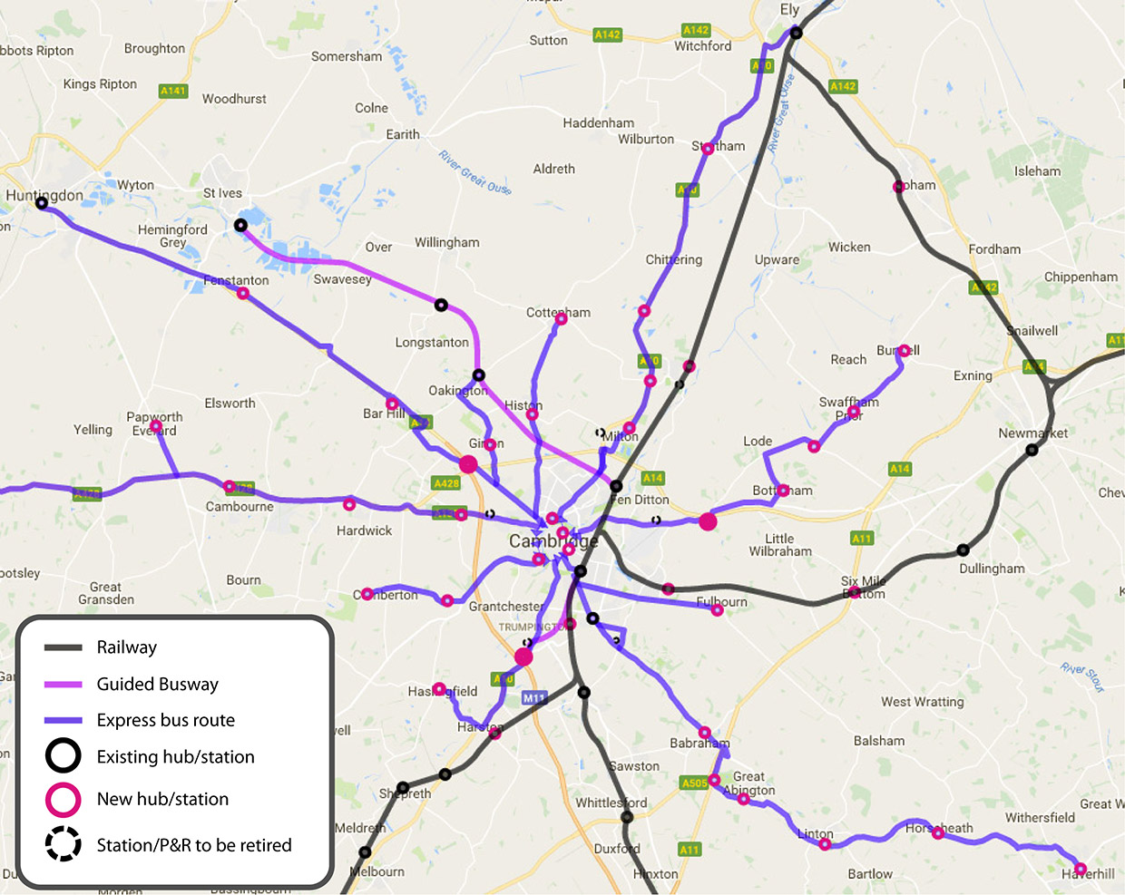
The size indication (Large, Medium, Small) relates to the amount of parking and other amenities that would be provided. Locations are listed in a roughly clockwise order.
North
| Location | Key features | Size | Requirements |
| St Ives | Busway, bus station | L | Upgrade waiting room |
| Also serves: Hemingford Abbots, Hemingford Grey, Needingworth | |||
| Longstanton | Busway, bus station | M | Already a good model for other sites |
| Also serves: Willingham, Over | |||
| Cottenham | Secondary school | S | Bus station |
| Waterbeach New Town | A10 | S | Bus station |
| Also serves: Landbeach | |||
| Waterbeach | Railway, A10 | S | Enlarge/move train station north |
| Also serves: Landbeach | |||
East
| Location | Key features | Size | Requirements |
| Soham | Railway | S | Train station |
| Also serves: Landbeach | |||
| Burwell | Wicken Fen | S | Cycle/footway to Wicken Fen |
| Also serves: Upware, Reach, Exning, Fordham | |||
| A14 Jn 35 | A14 | L | Bus station |
| Also serves: A14 from east, Stow-cum-Quy | |||
| Newmarket | Railway, A14 | S | Upgrade train station |
| Dullingham | Railway | S | |
| Also serves: Stetchworth, Woodditton, Burrough Green | |||
| Six Mile Bottom | Railway, A11 | S | Train station |
| Also serves: Westley Bottom, West Wratting, Balsham, Great Wilbraham, Little Wilbraham | |||
| Fulbourn Hospital | Railway | S | Train station |
| Also serves: Cherry Hinton, Teversham | |||
South
| Location | Key features | Size | Requirements |
| Linton | Secondary school | S | Bus or train station |
| Also serves: Balsham, Hadstock, Bartlow | |||
| Babraham | A11 | S | Bus station |
| Also serves: Babraham Institute | |||
| Whittlesford Parkway | Railway, A505 | L | Upgraded train station and enlarged car park |
| Also serves: Duxford, Sawston, Pampisford | |||
| Meldreth | Railway | S | Improved cycle/footway to Melbourn |
| Also serves: Melbourn | |||
| Shepreth | Railway, Wildlife Park | S | |
| Also serves: Barrington | |||
| Foxton | Railway, A10 | M | Car park |
| Also serves: Barrington, Fowlmere, Thriplow | |||
| Harston | Railway, A10 | S | Train station |
| Also serves: Hauxton, Newton, Haslingfield | |||
| Trumpington | Existing P&R, Busway, M11, A10 | L | Plan for light rail link to central station and city centre |
| Also serves: M11, Grantchester | |||
West
| Location | Key features | Size | Requirements |
| Haslingfield | S | Bus station | |
| Also serves: Harlton, Little Eversden, Great Eversden, Barrington | |||
| Comberton | Secondary school | M | Bus station |
| Also serves: Barton, Toft, Little Eversden, Great Eversden | |||
| Barton | A603 | S | Bus station |
| Cambourne | Secondary school, A428 | L | Bus station |
| Also serves: Caxton, Elsworth | |||
| Fenstanton | A14 | S | Bus station |
| Also serves: Hemingford Abbots, Hilton, Conington, Fen Drayton, Fen Drayton lakes | |||
| Girton Interchange | A14, A428, M11 | L | Bus station |
| Also serves: A14 (north-west), A428 (west), Madingley | |||
Express Stops
A few of the more significant express stops (which are not marked on the map above) would include:
North
| Location | Key features | Requirements |
| Swavesey | Busway, secondary school | Larger car park |
| Also serves: Over | ||
| Northstowe | New development, busway | |
| Oakington | Busway | Car park |
| Also serves: Girton, Cottenham | ||
| Girton | Route some Guided Busway services via Girton and Huntingdon Rd. | |
| Also serves: Oakington | ||
| Histon & Impington | Busway, secondary school | Set-down/pick-up areas & cycle parking at busway stop and close to Junior School |
| Milton | Milton Country Park | |
| Cambridge Science Park | Business parks | Local shuttle service |
| Also serves: St John’s Innovation Park, Cambridge Business Park | ||
East
| Location | Key features | Requirements |
| Lode | Anglesey Abbey | |
| Bottisham | Secondary school | |
| Fulbourn | ||
| Also serves: Great Wilbraham, Little Wilbraham | ||
| Newmarket Road | Existing P&R | |
| Also serves: Fen Ditton, Horningsea, Teversham | ||
South
| Location | Key features | Requirements |
| Great Shelford | Railway | More cycle parking, set-down/pick-up area |
| Also serves: Little Shelford, Stapleford, Sawston | ||
| Biomedical Campus | Busway, bus station | Upgraded bus station, local shuttle service |
| Also serves: Long Road Sixth Form College | ||
| Granta Park | Science park | |
| Also serves: Great Abington, Little Abington, Hildersham | ||
| Hinxton | Wellcome Trust Sanger Institute | |
| Also serves: Ickleton, Great Chesterford | ||
| Sawston | Secondary School | |
| Also serves: Pampisford | ||
West
| Location | Key features | Requirements |
| Papworth Everard | ||
| Also serves: Hilton | ||
| Bourn Airfield | Development proposed in Local Plan | |
| Also serves: Bourn, Knapwell, Boxworth, Highfields Caledcote | ||
| Hardwick | ||
| Also serves: Highfields Caledcote, Toft | ||
| Fenstanton | ||
| Also serves: Hemingford Abbots, Hilton, Conington, Fen Drayton, Fen Drayton lakes | ||
| Bar Hill | ||
| Also serves: Dry Drayton | ||