
Contents
- Overview
- Responses to proposed short-term measures
- Responses to proposed long-term ‘strategies’
- Alternative proposals
- Mass transit options
This consultation response paper is available as a downloadable document here.
Overview
Smarter Cambridge Transport supports most of the short-term measures proposed (some with modifications), but believes that these alone are inadequate to address the urgent transport needs of the Biomedical Campus, with Papworth Hospital, Abcam and AstraZeneca opening their doors over the coming year. If Greater Cambridge Partnership does not act quickly and decisively to increase public transport capacity and attractiveness, two more car parks (already granted outline planning consent) will inevitably be built on the Biomedical Campus, with potentially disastrous consequences for the local road network and ambulance response times.
Recognising this, we have proposed a series of measures to provide significant priority to buses, and safety improvements for people walking and cycling, which could be delivered quickly and cheaply, with minimal environmental damage. To this we have added a number of longer-term complementary interventions that would increase access to existing railway lines, and incentivise more people to cycle instead of drive.
Smarter Cambridge Transport does not support any of the three long-term strategies proposed. We fully accept the need to increase transport capacity between Cambridge and Haverhill, but want to see a fair and realistic comparison of the three mass transit options: heavy rail, light rail and bus rapid transit. There is too much that is unclear, uncertain and unproven, and hence risky, about the proposed bus-based mass transit technology, which is not yet in regular service anywhere in the world.
Strategies 2 and 3 do not provide sufficient long-term benefit to warrant the environmental damage their construction will cause. It makes no sense to build a bus lane to bypass people driving to catch a bus at the Babraham Park & Ride. We need public transport options from close to home to be more attractive than Park & Ride.
About this response
Smarter Cambridge Transport is an entirely voluntary community group seeking to advance integrated and sustainable transport for the Cambridge region. This response represents many days of research and analysis by an extended group of experts in various fields, and local residents. We will be happy to meet with the Greater Cambridge Partnership to discuss any of it.
Disclaimer
We have not been able, in advance of submitting this response, to consult with all the councillors, parish councils, residents associations, businesses, interest groups and landowners who may be affected by the proposals we have set out here. This website version of the document invites further comment. If we have inadvertently misrepresented or misjudged local needs, we will amend our response and notify Greater Cambridge Partnership.
Responses to proposed short-term measures
These points are numbered to match the Greater Cambridge Partnership Cambridge South East Transport Study brochure.
S1. Granham’s Road junction: We support addition of right-turn filter lane. We are unclear why simplification of the junction will improve safety as the current design reduces conflict between vehicles turning right.
S2. Babraham P&R: We support addition of cycle parking and electric car charging points. We would like clarity on whether users will be expected to pay to use charging points and how. We would also like confirmation that proprietary charging points (e.g. Tesla) and any supporting infrastructure (e.g. substation) will be funded by third parties.
S3. Linton Greenway: We support safety improvements to junctions along the existing cycleway and limited widening and/or greater separation from the carriageway. However we do not believe that the principle cycle route between Babraham Research Park and the Biomedical Campus should be alongside the A1307. This route involves a long climb in both directions, and is unpleasant to ride in the dark when riders are constantly dazzled by car drivers’ headlights. We believe that a second route should be built via Stapleford (see below).
S4. Haverhill Road/Gog Farm Shop: We oppose the redesign proposed for the Haverhill Road junction as over-engineered. We support the addition of a right-turn filter lane into the farm shop access road. We support the extension of the 50mph speed limit. Our alternative proposal for this junction is outlined below.
S5. Wandlebury multi-user underpass: We oppose the creation of an underpass as over-engineered. The proposed design does not accord with visibility and usability standards set out in Interim Advice Note (IAN) 195/16. Creating straight approaches to provide good visibility would require a large land take and create an ugly concrete structure that would be inappropriate for this location. Our proposal for this crossing is outlined below.
S6. Babraham Research Campus roundabout: We support the addition of a new signalised crossing here.
S7. Eastbound bus lane at A11: We support the reallocation of a filter lane to a bus lane and, subject to further detail, safety improvements at the Babraham High St junction.
S8. Multi-user crossing of A11: We neither support nor oppose the proposed addition of ramps until it is clear that the bridge may also be widened to at least 4m to be fully accessible, and that the total upgrade cost is reasonable. At the moment it is not possible for two cycles or a cycle and a push chair to pass safely, even at low speed. We also propose an alternative route to the south that would connect more directly to Granta Park – see below under Cycle Greenways. Only if the bridge upgrade goes ahead do we support the proposed changes to the approach paths to the bridge (there is no need to make the path more ‘urban’ if it is to remain as a footway).
S9. Hildersham crossroads: We support the addition of Toucan/Pegasus crossings as proposed.
S10. Linton Village College approach: We support the conversion of carriageway to a bus lane. However we suggest it should operate at all times so as to reduce confusion for car drivers and the amount signage required to indicate the hours of operation.
S11. Linton Village College junction: We support upgrading the traffic signals.
S12. Linton High Street junction: We support the proposed modifications to the signals and pedestrian crossing. We can neither support nor oppose the right-turn ban until the consequential impacts are better understood. We suggest trialling the ban with an Experimental Traffic Regulation Order.
S13. Linton: We support efforts to work with Linton Parish Council to improve the attractiveness and reliability of bus services.
S14. B1052 junction approach: We can neither support nor oppose the addition of a westbound bus lane until the likely benefits and environmental impacts are known. We support the objective of providing significant bus priority.
S15. Bartlow Road roundabout: We can neither support nor oppose the proposed changes until the impacts are clearly understood. It may be that restoring the cross-roads as a ‘smart’ light-controlled junction is more efficient and safer for people cycling and walking (e.g. from Bartlow to the travel hub). We are not convinced that it is appropriate to locate a travel hub (essentially a car park) at this location: who is it for? There is a need for a travel hub to serve Linton residents, to give them access to express bus services following the A1307 and not diverting via the High St. A location close to the Village College would be more appropriate. Similarly Horseheath would be better served by a travel hub close to the village, possibly by the Linton Rd junction.
S16. Horseheath to Linton: We support the reduction in speed limit. We understand the intention to improve safety at the Dean Rd junction, but question whether the proposed diversions are proportionate, for instance for farmers moving agricultural machinery. The diversion via the Bartlow Rd roundabout if exiting Dean Rd from the south is 2 miles; the diversion if exiting Dean Rd from the north is not described. People may try to turn around at the Horseheath Rd junction to the west and the Horseheath Racecourse junction to the east. Would this be safer than now?
S17. As S16.
Responses to proposed long-term ‘strategies’
For reference the first-estimate benefit-cost ratios (BCRs) for the proposed schemes are:
| Scheme | Benefit | Cost | BCR |
| Strategy 1 | £280–320m | £130–145m | 1.9–2.5 |
| Strategy 2 | £165–180m | £42–46m | 3.6–4.3 |
| Strategy 3 | £145–165m | £39–44m | 3.3–4.2 |
Strategy 1 (busway from A505)
We oppose this strategy because there are significant concerns and in need of addressing, and too many unknowns on which it depends.
- It is unclear at this stage whether the benefits justify the environmental costs of constructing a new bus-only road, with associated drainage systems.
- As an alternative to Strategies 2 and 3, the economic case is also unclear. It has the lowest benefit-cost ratio and the longest delivery timeframe. Something is needed now to start to induce significant modal shift to buses and cycling; otherwise the rapid growth of the Biomedical Campus threatens to paralyse the road network.
- How would this route connect with the Addenbrooke’s Rd roundabout? The Abcam development and planned multi-storey car park will block access from the south. It would appear that there is insufficient space under the Addenbrooke’s Rd bridge to accommodate both a busway (even a single lane) and a cycle/footway at a safe distance. If the busway were taken under the bridge, then there would need to be a pedestrian/cycle crossing and a new link to the roundabout. It will be difficult to design these to be as safe and convenient as now for people walking and cycling.
- How will this connection avoid encroaching on, and potentially damaging the ecology of, the Nine Wells Nature Reserve?
- There is concern that the route around the north of Stapleford and Great Shelford encloses an area that would be seen as ripe for development. It is essential that future land use is planned with proper thought and consultation first.
- The implied use of the old railway alignment east of Sawston does not serve Babraham Institute or village well, being over 1km from both across open countryside. This would be unappealing to walk in the dark or rain.
- Parts of the old railway alignment now have a rich ecology and are designated County Wildlife Sites.
- The connection with the A505 slip ramp requires more detail: How will this be made safe, especially with articulated vehicles joining or crossing the carriageway?
- How would the proposed Park & Ride next to the A505 be accessed?
- How would the busway continue east to Linton and Haverhill? Or does this already concede that the A1307 will be dualled east of the A11, undermining – potentially for a decade or more – the business case for investment in sustainable transport alternatives?
We need a coherent, integrated, long-term transport strategy before building major new infrastructure. As set out below, one of the options that should still be under consideration is the reinstatement of a railway line between Great Shelford and Haverhill.
Strategy 2 (busway from Babraham P&R)
We oppose this strategy because it ‘bakes in’ reliance on Babraham Park & Ride as the most attractive way to access the Biomedical Campus and the city. This is not a sustainable strategy for the long term, and undermines efforts to improve public transport from further afield.
Park & Ride is an interim solution. It does not serve people who do not have access to a car. It attracts traffic to the edge of the city, where it contributes to congestion. That in turn necessitates widening roads to provide extra capacity for cars to access the Park & Ride sites, and for buses to overtake the queuing cars.
Like Strategy 3, it also takes more land for a bus lane than is necessary to provide sufficient bus priority to start a virtuous cycle of public transport becoming quicker and more convenient than driving and parking. Inbound Flow Control, as set out below, can provide similar bus priority at far less expense, with lower environmental impact, and in a much shorter timeframe.
Specific questions and concerns include:
- How will this connection avoid encroaching on, and potentially damaging the ecology of, the Nine Wells Nature Reserve?
- How would this route connect with Dame Mary Archer Way?
- We can anticipate that the P&R car park will fill up with hospital day-shift workers, who typically start around 7am. What about people arriving later to find the car park full? Their options will be to park on residential streets, or one of the Biomedical Campus or city car parks. How will load balancing of the two sites be managed to avoid this happening?
Strategy 3 (bus lane)
We oppose this strategy because it takes more land for a bus lane than is necessary to provide sufficient bus priority to start a virtuous cycle of public transport becoming quicker and more convenient than driving and parking. Inbound Flow Control, as set out below, can provide similar bus priority at far less expense, with lower environmental impact, and in a much shorter timeframe.
Widening Babraham Rd within the city boundary severely compromises provision for walking and cycling and entails the loss of verges and trees, which should always be a last resort.
Inbound Flow Control, as set out below, can provide similar bus priority at far less expense, with lower environmental impact, and in a much shorter timeframe.
Park & Ride site
The location and size of a Park & Ride site is not part of this consultation, even though it is integral to each of the three ‘Strategies’. Until it is known where people are travelling from, it is not clear whether this is the right location for a Park & Ride. It could undermine the No.13 Haverhill bus services east of the A11 by encouraging people to drive to the P&R and gain access to a more frequent service from there (dedicated P&R plus No.13 services).
Traffic arriving via the A11 from the north may be better intercepted on the Newmarket railway line. The infrequency of the current service makes it unattractive for commuting, but capacity upgrades are planned as part of East-West Rail. Add stations at Fulbourn Hospital and Six Mile Bottom, with direct services to Cambridge South, and this will become a popular line for commuting and other trips.
Before East-West Rail arrives, a P&R site on the south side of the Stow-cum-Quy interchange (replacing the one on Newmarket Rd) could serve people well if bus services ran into the city via Addenbrooke’s.
Traffic arriving via the A11 from the south may be better intercepted on the Liverpool St railway line, for instance at an expanded and upgraded Whittlesford Parkway station. With direct services to Cambridge South, this would be a fast and reliable way to reach the Biomedical Campus.
Because there will be other more convenient locations for people to use in future years, the parking capacity required at this location is unlikely to be as much as the 1,400 to 2,000 currently forecast.
Alternative proposals
We see Strategy 3 as a viable short-to-medium term measure if road widening is avoided as far as possible, and alternative measures are introduced to increase bus priority and safety for all road users. We call this ‘Strategy 3a’. Interventions are shown in the map below.

Strategy 3a (optimal)
We believe there is a more effective solution than Strategy 3 that can be delivered more quickly and cheaply with lower environmental impact. The main component of the strategy is to implement Inbound Flow Control using the existing infrastructure as far as possible.
This will incentivise modal shift to buses, providing some immediate relief to pressures on roads and parking at and around the Biomedical Campus. It will buy time to develop a longer-term strategy that accommodates future growth within a properly-developed and coherent spatial (including landscape), economic and transport strategy.
Fourwentways to Wandlebury

A1. Change the speed limit to 50mph between Fourwentways and 200m to the east of the Wandlebury entrance, and 40mph west from there to Hinton Way roundabout (which is already in a 40mph zone). This would go some way to address the poor safety record around junctions on this section of the A1307, especially at Babraham High St (shown here). Note that this would slightly increase road capacity in terms of vehicles/hour (this needs stating as it is counterintuitive).

A2. Consider creating a P&R site within the lozenge of land immediately to the south of the Fourwentways interchange (shown here). This could be served by No.13 services and, at least at peak times, additional services starting at Granta Park. This would also serve people working at and visiting Granta Park a direct service from Cambridge. This might also link with a shuttle service along the A505 between Granta Park and IWM Duxford (see Bus Services below for more detail).
Wandlebury
A3. Convert the inside lane of the dualled and previously-dualled section of the A1307 past Wandlebury to a bus lane (1,130m). This would allow buses to overtake 100–150 vehicles at peak times.
A4. Consider options for a light-controlled junction with crossing (see Haverhill Rd junction below).
A5. Consider relocating the bus stops closer to the crossing (where they would also serve the farm shop better).
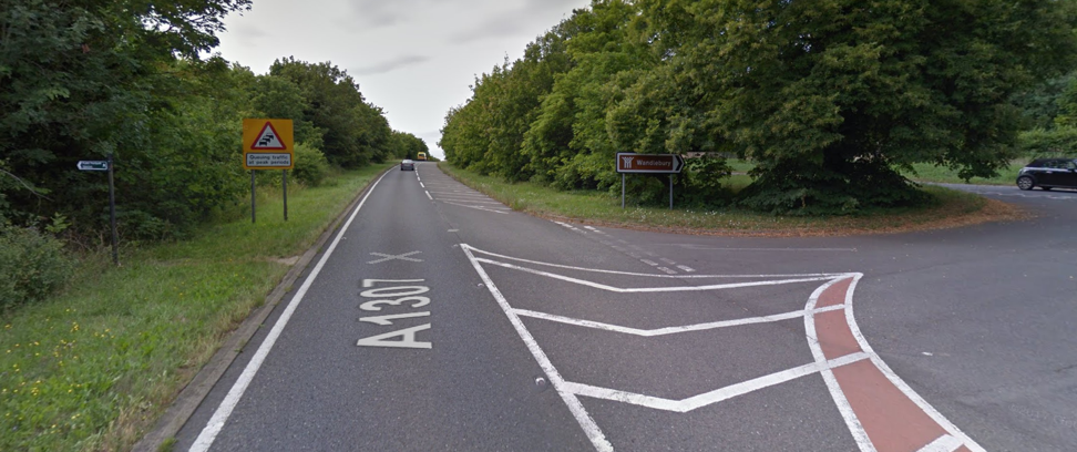
A6. Improve the safety of the pedestrian crossing between Wandlebury and the Magog Down (where there is a public footpath – shown here), e.g. by creating a footway across the central reservation.
Babraham P&R and Worts’ Causeway
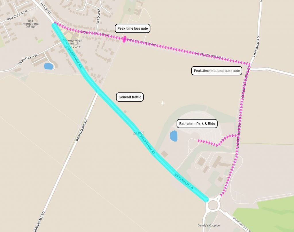
A7. Update the existing access restriction on Worts’ Causeway to act as a bus gate during peak hours. At these times, the only vehicles using Worts’ Causeway east of the bus gate (where there are no houses) would be buses travelling towards the city. This would include services from Babraham P&R and Haverhill (service 13). Consult with local residents about extending the hours of restricted access to deter rat-running.
A8. Within Babraham P&R, add an outbound bus lane from the bus station alongside the car park entry lane to enable buses to exit directly onto Cherry Hinton Rd at peak times. This would give buses access to Cambridge via Worts’ Causeway, avoiding congestion on Babraham Rd. The detour would be just 430m (about 45 seconds).
A9. Re-configure the Hills Rd–Worts’ Causeway junction to optimise traffic flows and reduce the green time required for the Worts’ Causeway exit. Include a ‘Hurry Call’ for buses approaching on Worts’ Causeway.
A10. Consult local residents on adding a peak-time inbound bus stop on Worts Causeway to provide some benefit from having buses run through their neighbourhood.
A11. Ensure that outline plans for development areas GB1 and GB2 (north and south of Worts’ Causeway) manage generated vehicle traffic so as not to delay peak-time bus services, and provide the best possible ‘filtered permeability’ to encourage walking and cycling to local amenities and bus stops.
Hinton Way roundabout to Worts’ Causeway junction
A12. Extend the 30mph zone, say, 100m south-east of the Granham’s Rd junction. This would increase safety at the junction and give traffic turning right into Granham’s Rd more opportunity to make the turn.
A13. Apply pressure to get the Ninewells development planning conditions delivered and opened ASAP: cycle/pedestrian crossing of Babraham Rd and new cycle/footway that will connect Babraham Rd via the Ninewells development to the Addenbrooke’s–Great Shelford cycleway.
A14. Extend the two-way cycle lane on the footway south from Red Cross Lane to Knightly Avenue (Ninewells), widening where necessary.
Worts’ Causeway junction to Addenbrooke’s roundabout
A15. Review on-street parking in residential streets in the area with the aim of phasing out free commuter parking and removing obstacles to buses (including on Worts’ Causeway). This would incentivise use of the improved public transport, and reduce traffic, congestion and pollution caused by drivers hunting for parking spaces. A residents’ parking scheme may not be cost-effective as most homes have off-street parking: income from visitor permits would be inadequate to cover the costs of enforcement. Another option would be an extension of single yellow lines, mixed with short-stay bays (say, up to 4 hours). These would need only occasional enforcement to deter daily commuters.
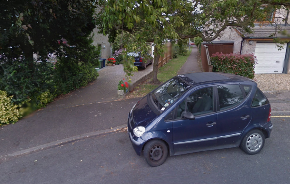
A16. Improve permeability for walking and cycling through the residential streets to the north of Worts’ Causeway. For instance, the link between Almoners’ Avenue and Bowers Croft appears to be officially a footway (shown here). To make is safer as a cycleway, it needs modifications, such as aligned dropped curbs protected by double-yellow lines (to facilitate access for less-manoeuvrable bikes and trikes), and small cycle direction signs. The previous recommendation would help address safety concerns for people cycling around here.
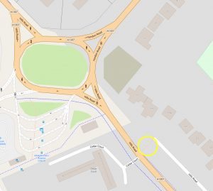
A17. Open up the pathway connecting Hills Rd with the parallel residential access road (shown here). This would enable cycle traffic to be diverted off the Hills Rd footways, reducing conflict between cycles and pedestrians.
Biomedical Campus
A18. Extend the route of the Biomedical Campus courtesy bus to the Babraham Park & Ride during hours when P&R buses are not running. This would overcome a reasonable fear that it isn’t safe to walk or cycle out to the P&R site late at night.
A19. There are two more multi-storey car parks planned to be built on the Biomedical Campus, with a combined capacity of 1,894 spaces. If these go ahead, we can expect far worse congestion on approach roads, which will affect ambulance response times. They would also undermine one of the main drivers for people to use public transport: insufficient parking at their destination. It is imperative that the Greater Cambridge Partnership acts decisively and quickly to implement measures to increase public transport capacity and attractiveness so that it is no longer deemed necessary to build these car parks.
Haverhill Rd junction
An option for the Haverhill Rd junction would be to make it a light-controlled junction with a Toucan/Pegasus crossing. This would have a number of benefits:
- Enables safe all-ways movements for vehicles.
- Provides a safe crossing for people walking, cycling and horse-riding, linking with a continuation of the shared use path alongside Haverhill Rd.
- Makes the Magog Down car park a safer alternative to the Wandlebury car park (which has limited parking).
- Enables Inbound Flow Control using the dualled section as queuing space, with a bus lane bypass. Traffic down the hill to Hinton Way roundabout would be regulated by the lights, ensuring that it is free flowing.
- This in turn would mean there is no need to widen the road between Haverhill Rd and Hinton Way roundabout for a bus lane. This is a highly visible stretch of road leading up onto the Gog Magog Hills. Widening it should be considered only if other measures proposed here deliver insufficient bus priority.
However there are cons:
- It’s not where the public footpath crosses Babraham Rd, which is a more attractive link between Wandlebury and Magog Down.
- It will be expensive to install – but not compared with digging out and maintaining an underpass, with associated drainage system.
- The lights are just beyond the brow of the hill, though visible from over 250m away travelling north-west. A reduction in the speed limit at this location would reduce the danger.
- Traffic lights introduce an inappropriately urban feel to a rural location. Operating the lights only between 7am and 6pm would mitigate this slightly.
- The non-motorised users crossing would span four lanes, which requires a relatively long crossing time. Analysis of when and how often it is likely to be used would determine the impact on motor traffic.
The junction design would need careful consideration. Babraham Rd westbound would probably need three lanes: one for buses only, one for traffic going straight-on or turning left, and one for traffic turning right. The light for the bus lane (leftmost) would be red when the straight-on/left lane was green, and vice-versa, ensuring no conflict between buses and left-turning traffic. The bus lane would gain a green light in advance of a bus approaching though use of a ‘Hurry Call’ arrangement. Buses would merge with the main drive lane across the junction.
Complementary measures
Cambridge South station
A new station serving the Biomedical Campus is absolutely critical to achieving significant modal shift from driving and parking there. A station here will amplify the benefits of adding new stations elsewhere on the network.
A20. Do everything necessary to get a new Cambridge South station open as soon as possible.
Sawston travel hub
A21. Ensure that a new railway station west of Sawston is included in the updated Local Transport Plan.
A22. In anticipation of having a new railway station to the west of Sawston, a much better location for a travel hub than that proposed by Skanska would be between the railway line and the A1301, to the north of Mill Lane. With a Toucan crossing of the A1301, this would be convenient for most of Sawston, including the college, and for the Spicers industrial site to the west. Served by a 7X bus service (see below) and additional services starting here at peak times, this would greatly improve access to Cambridge from the south.
Whittlesford travel hub
This will be the most important travel hub south of Cambridge and is currently subject to a masterplanning exercise.
A23. As an urgent priority, work with Greater Anglia and Network Rail to install a wheelchair (and cycle) accessible bridge over the tracks.

A24. Also, as an urgent priority, build a bus turnaround facility on Station Rd East, even just on a temporary basis, to enable buses to call at the station. A possibility might be a mini-roundabout opposite the entrance to the Highways England depot, ‘borrowing’ a piece of the verge (shown here).
A25. If feasible, create space on Station Rd West for buses to turn around.
A26. Seek ways to provide bus prio rity on the A505 between the A1301 roundabout and the Station Road East. This would benefit the proposed Citi 7X and A505 shuttle service.
Hinxton railway station
A27. Include provision of a new railway station at Hinxton in the next Local Transport Plan. This would serve Hinxton, Ickleton and the Wellcome Genome Campus.
Newmarket railway line
A28. Already featured in the Local Transport Plan, a new station is urgently needed to serve Cherry Hinton (including the new 1,200 home development north of the village), Fulbourn, Teversham, Peterhouse Technology Park, Capital Park and Fulbourn Hospital. The site we propose, subject to investigation and consultation, is at the point where Fulbourn Old Drift used to cross the railway line.
A29. Include provision of a new railway station with a large car park at Six Mile Bottom in the next Local Transport Plan. With direct access from the A11, this would serve people living in villages east of Cambridge, who are poorly served by public transport. Existing stations, such as Newmarket, Dullingham and Kennett have small car parks (10–12 spaces), and so cannot serve a wide customer base.
A30. Lobby East-West Rail to prioritise reinstating a double-track between Cambridge and Newmarket, to enable an increase in the service frequency.
Stow-cum-Quy P&R
A31. It is already planned to relocate Newmarket Park & Ride further out of the city. We propose that a site just south of the A14 interchange at Stow-cum-Quy would be the optimal location to intercept traffic. Inbound Flow Control could be used to regulate traffic flows along the A1303 and provide bus priority. If P&R buses ran via Addenbrooke’s and the city centre (in alternate directions), this would provide an attractive alternative to driving to Babraham P&R or to a new P&R on the A11.
M11–A11
A32. Press Highways England to build connecting slip roads between the M11 north and A11. This would enable northbound traffic from Saffron Walden, Chesterford Research Park, Little Chesterford, Great Chesterford, Ickleton, Hinxton and Wellcome Genome Campus to access the M11 via the A11–A1301 interchange, rather than congesting the A1301 and A505. It would also increase resilience of the Strategic Road Network by providing a continuously dualled alternative route around Cambridge when there is an incident on the A14 north of Cambridge.
Bus services
Review bus routes and services with Stagecoach and Whippet and businesses (such as Wellcome and Granta Park) that run private works buses and foot a large taxi bill:
A33. Rationalise the services, signage and ticket prices for trips between Cambridge station and the Biomedical Campus. This needs to be a painless interchange for thousands of people a day (until Cambridge South opens).
A34. Ensure that all bus services to the Biomedical Campus start early enough to arrive in time for the morning shift change around 7am.
A35. Run more 13 services (in particular the express X13), as these are often full to capacity.
A36. Split the Citi 7 service into two services from Saffron Walden: Citi 7X (‘express’ via the B184 and A1307) and 7 (‘local’ via villages between the M11 and B184/A1301) – shown below:

- Citi 7X: hourly (half-hourly at peak times) from Saffron Walden via Great Chesterford, Wellcome Genome Campus (stop on roundabout), Hinxton*, Whittlesford Parkway, Sawston, Stapleford, Great Shelford, Biomedical Campus, Cambridge station, Cambridge city centre.
- Citi 7: hourly from Saffron Walden via Audley End Estate, Littlebury, Great Chesterford station, Ickleton, Hinxton, Duxford, IWM Duxford, Whittlesford Parkway (as close as possible to the station, ideally using a turnaround on Station Rd West), Whittlesford, Little Shelford, Great Shelford, Biomedical Campus, Cambridge station, Cambridge city centre.
(*We propose upgrading the footway from the A1301 to the church and through the church yard to Church Green, and adding a bus stop on the A1301).
A37. Consider terminating 7/7X services at Cambridge station with a free transfer to any Stagecoach service to the city centre if this makes a more frequent service more viable. (Buses would turn around the block as the ‘R’ does now until a turning circle is provided at the station – see next point.)
A38. As an urgent priority, work with Greater Anglia, Network Rail and Brookgate to agree and implement a design for a bus turnaround at the station.
A39. Consider running buses via the guided busway between Addenbrooke’s and Cambridge if this will reduce journey time and variability owing to congestion on Hills Road.
A40. Extend the 26 service to the Biomedical Campus via the busway.
A41. Bring forward plans for a travel hub at Foxton, so that it can be served by additional buses running directly to the Biomedical Campus.
A42. Discuss with Granta Park and IWM Duxford subsidising a shuttle service along the A505 between the two locations, calling at Whittlesford Parkway station (with a bus turning circle – shown in A24 above). A single bus could provide a 20–30 minute frequency service.
A43. At least at peak times, a P&R at the A11 will require additional services to the No.13s. This could start at Granta Park so as to provide a direct connection between Cambridge and Granta Park.
Cycle greenways
Improving cycle links between villages (especially those with secondary schools), employment sites and Cambridge typically has the highest benefit-to-cost ratio of all infrastructure schemes. The 2011 Census indicates that 24.6% of commutes within the Greater Cambridge area are by bicycle. There is therefore still huge potential for modal shift in places that are not currently well served.
Sawston has poor provision within the village. The route through Stapleford avoiding the A1301 has many conflict points and unsafe crossings. The route between Babraham and Cambridge is hilly and especially unpleasant in the dark. Further afield, Duxford, Pampisford, the Imperial War Museum Duxford, Granta Park, the Abingtons and Linton have very little provision suited to an 8–80 age range.
A44. Invest more resource and urgency into developing a greenways network, not just commuter routes radiating out of Cambridge city.
A45. Secure a continuous cycle/footway from Great Shelford station to the north edge of Sawston, connecting with the new Cambridge City football ground and the Sawston–Babraham cycleway. To achieve this, use the existing Sustrans agreement from Network Rail and incorporate the permissive path around the recently completed agricultural reservoir. Where the railway alignment now has high ecological value (in particular where it is designated as a County Wildlife Site), the cycleway should run alongside it, preserving the established habitat as a linear park. The route may be required in future as a mass transit route – see below.

A46. If the existing footbridge over the A11 is upgraded to be a cycleway, then continue the cycleway on the east side of the A11 with a new/widened shared use path (wide enough for people cycling to pass safely) on the east side of north-south part of Bourn Bridge Rd and Newmarket Rd between the Granta Park roundabout and the Travelodge. Crossing the River Granta will require either the road to be pinched or an extra bridge. Continue the cycleway east to Little Abington with a new shared use path alongside Bourn Bridge Rd east to the edge of the village (where the 30mph zone starts). See map.
A47. Alternatively, or in addition, create a new path from the existing farm track west of the A11 via the underpass, alongside the River Granta, to Bourne Bridge Rd. Or, route the path to the A505 slip ramp (see next paragraph). See map above.
A48. Complete the cycleway from Whittlesford Parkway to Granta Park, which currently ends disconcertingly and unsafely on the A505 slip ramp. Making the north side slip ramp exit-only, would release space for a high quality segregated cycleway, including under the A505, where space is most constrained. The cycleway should continue on the north side of Station Rd (A505 connector) to the Granta Park roundabout. This will require modifications to the bridge over the A11, possibly by slightly narrowing the carriageway and raising the bridge parapet on the north side.
Mass transit options
Clearly there is a need to provide additional transport capacity between Cambridge and Haverhill. Bus priority and more bus services along the A1307 will incentivise modal shift. However, it is unlikely to provide a quality of service that will attract sufficient modal shift to offset growth in jobs and housing in the ‘corridor’.
This part of South Cambridgeshire, with views of and from the Gog Magog Hills and Magog Down, is of high environmental, ecological and aesthetic value. In order to preserve this exceptional natural asset for future generations, there needs to be a landscape strategy and a Sustainability Appraisal (in accordance with the Strategic Environmental Assessment Regulations) underpinning future development and transport infrastructure.
At the moment we believe there is insufficient evidence to choose either the alignment or the mode. Significant unknowns include:
(note: MTL = Haverhill–Cambridge mass transit line)
- Where does traffic on the A1307 originate? How much originates from the A1307 ‘corridor’, and how much from further afield (principally via the A11)?
- Are there better opportunities to capture that traffic further away, e.g. on existing railway lines, enhanced with new stations and more frequent services?
- What exactly is the ‘CAM’ proposal with which GCP are proposing the MTL would link with? The MTL seems to depend on the viability of the ‘CAM’ proposal, which depends on technology (not just being autonomous, but optical guidance at speed) that does not yet exist in the field. The requirement to be compatible with the existing guided busway adds a further technical challenge.
- How will the MTL serve Babraham Institute and village?
- How will it connect with a new P&R next to the A11?
- How and where will the MTL cross the A11?
- Along what alignment will the MTL continue to Haverhill?
- How will upgrades to the Newmarket railway line affect the business case for the MTL? This could include new stations at Fulbourn Hospital (no car park) and Six Mile Bottom (with a car park), and increased service frequency (following double-tracking the line as part of East-West Rail).
- How will the MTL serve North Uttlesford New Town, if that goes ahead?
- How does this fit with proposals to build a new dual carriageway between the A11 and Haverhill? If a new road were built from Haverhill south of the A1307, it could potentially provide a connection to Whittlesford Parkway, which could and should be a major travel hub for the region, providing rail connections to Cambridge, Biomedical Campus (at Cambridge South station), London, Stansted Airport, etc.
- We believe that the benefit-cost ratio of a heavy rail option was severely underestimated by WSP, and should be examined again (see below).
- We believe that light rail has not been evaluated fairly as a mass transit option, and should be examined objectively as part of the mass transit options business case being commissioned by the Combined Authority.
Strategy 4 (rail)
Heavy rail
We believe that a heavy rail link between Great Shelford and Haverhill was excluded on the basis of a flawed assessment. The Draft Rail Viability Technical Note by WSP, published in November 2015 concluded that a single-track heavy rail link to Haverhill had a BCR of 0.99 and therefore was too poor value to continue.
WSP’s forecast was for 1.8m trips (one-way) per year. The Guided Busway carries 4m trips per year. The current population served by the St Ives Busway is about 36,000. The population that would be served by the Haverhill railway in 2030 will be in excess of 55,000 – or 68,000 if North Uttlesford New Town goes ahead.
Council officers confidently assert that the Cambourne to Cambridge busway will quickly reach a similar patronage to the existing busway, even though the population served is not expected to have grown much beyond 30,000 by 2030, and a large proportion of the existing busway’s 4m trips are actually on the Trumpington section, or don’t touch the busway at all.
Extrapolating from the St Ives busway to the Haverhill railway provides a forecast of about 3.75m trips/year.¹ With an average single fare of £2.50, that yields £560m revenue over 60 years (at today’s prices). This translates to a BCR of 1.85. This is similar to the BCR for Strategy 1.
That BCR is a first approximation. It does not take into account:
- The exceptionally large employment base that would be served by the railway: Cambridge Biomedical Campus, South Cambridgeshire Business Park (Sawston), Babraham Institutute, Granta Park and Haverhill Business Park.
- More detailed analysis of time benefits of travelling by rail instead of car: shorter journey times (including allowance for variability in congestion delays), and travelling time spent more productively.
- Rail could take some of the freight off the road too. Haverhill’s economy is dominated by industry, so having direct access to Felixstowe and the rest of the rail network (which will include East-West Rail by 2035) could be attractive.
¹ The forecast ridership assumes that two thirds of current busway trips are on the St Ives to Cambridge section, based on the number of passenger-seats available on buses arriving in Cambridge between 8 and 9am on a weekday: 1,140 on the St Ives busway (services A, B, N and C), 528 on the Trumpington busway (services A, R and U). We have excluded 5% of the 4 million annual busway trips as an estimate of the number of trips that do not touch the busways. That provides a figure of just over 2.5 million for passenger journeys on the St Ives busway. Multiply it by the relative size of the populations served (just over 50% more in the Haverhill–Cambridge corridor) to arrive at a forecast ridership of 3.75m trips/year.
Light rail
We believe that the Steer Davies Gleave report on Mass Transit Options was deeply flawed. It failed to distinguish between the network and mode. It wrongly concluded that light rail is too expensive for Cambridge, in part because it considered only two sizes of network: 42km or 90km. A smaller network (highly integrated with buses and heavy rail network) would be more appropriate for Cambridge in the 2030s (though it would of course be wise to plan for future extensions).
There are at least fifty light rail networks around the world that serve city regions with a population under 250,000. The population of Cambridge and its necklace villages, currently close to 170,000, is likely to reach 250,000 in the 2030s.
By contrast, only a handful of guided busways have been built. Almost all of these, including the Cambridgeshire Guided Busway, have experienced serious problems and cost overruns. Two installations have been replaced with light rail (in Caen and Edinburgh); others have been decommissioned; in most other cases, planned expansion has been curtailed.
Optical and magnetic guidance, and autonomous driving in mixed traffic are all unproven technologies. We should not be risking large amounts of public money on these.
There is a peculiar professional prejudice in Britain, not found on the Continent, against building light rail. Yet light rail is hugely more popular with the general public than the alternative, buses. There is much we can and should do to improve bus services; but where demand is sufficiently high, light rail is the more efficient and attractive option.
Recommendations
A49. Secure the old Haverhill railway alignment between Great Shelford station and the north edge of Sawston for possible future use as a mass transit route: either heavy rail, connecting to the main line at Stapleford; light rail running alongside the main railway line; or bus rapid transit. In the short term, it should be opened up as a cycle/footway (see above).
A50. Re-evaluate the heavy rail option for linking Cambridge and Haverhill.
A51. Ensure the brief for the Mass Transit Options business case examines the case for light rail objectively, separating out the network design (which should be determined primarily by demand, not mode) and the appropriate mode to meet demand on different parts of the network.
A52. Re-evaluate the viability of a mass transit route alongside the railway from south of Stapleford to the Biomedical Campus (rather than skirting around the north of Stapleford and Great Shelford).
A53. Commission (or compile from existing studies) a transport assessment of the wider Cambridge–Haverhill wedge that looks at the wider needs and options. That needs to include a reliable origins and destinations survey, cross-checked against the 2011 Census data (which is out of date and only covers commuting).
A54. Examine in detail how a non-heavy rail option will integrate with whatever mass transit option is developed for Cambridge, to provide through services to the city centre.
General comments are welcomed below. If you have any recommendations for ways in which the ideas above might be approved or expanded, please email us at info@smartertransport.uk
Makes absolute sense to reinstate the old rail route instead of bulldozing through arable land and back beautiful views!.