
Our response offers ideas and commentary on the Greater Cambridge Partnership proposals for improving access to Cambridge from the east by cycle, bus and rail. Codes in brackets refer to scheme components in the Options Appraisal Report.
Cycleways
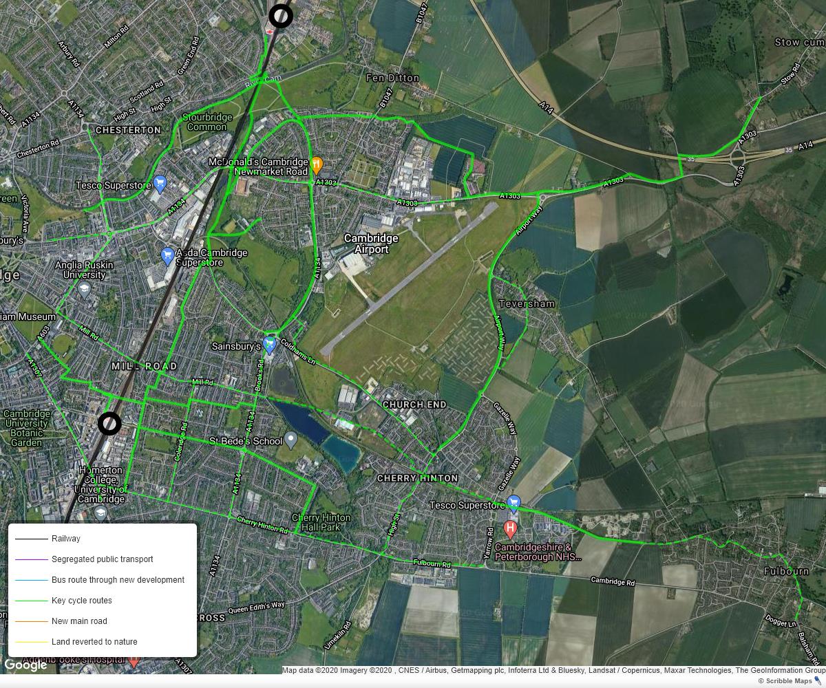
Cycleways in east Cambridge are of mixed quality with few direct routes being of high quality (see Figure 1). There are many busy junctions and roundabouts that are difficult for people walking and cycling to negotiate safely and quickly. Much more investment is needed to improve safety at those junctions, and to create new protected cycle lanes on key desire lines, such as along Coldhams Lane (west and east of the Barnwell Drive roundabout), Newmarket Rd, Cherry Hinton Rd and Brooks Rd.
Coldhams Lane (AT.06)
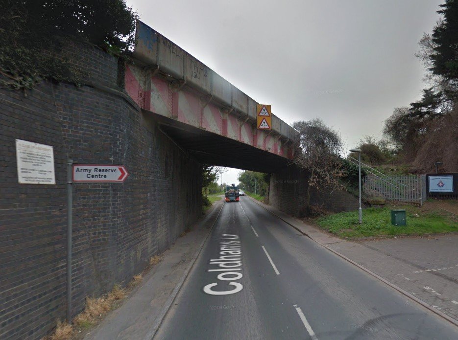
The challenge with creating a safe cycle route alongside Coldhams Lane is greatest at the railway bridge, which is too narrow to accommodate protected cycle lanes, yet alone standard-width footways (see Figure 2). The only viable alternative route is via Nuttings Road, which works for people heading for Barnwell Rd, but less well for the majority heading for Brooks Rd.
There could be value in having:
- a two-way cycle lane on the north side of Coldhams Lane between Nuttings Road and Rosemary Lane;
- a parallel (pedestrian and cycle) crossing of Barnwell Road opposite Uphall Rd;
- a parallel crossing of Coldhams Lane just to the east of The Paddocks;
- protected or raised cycle lanes along both sides of Coldhams Lane between the roundabout and Cromwell Road junction.
Although not ideal, it would provide a safer cycling route between Cherry Hinton, the Beehive Centre and the Chisholm Trail before the roundabout is redesigned and the railway bridge is widened or dismantled.
Priority parallel (pedestrian and cycle) crossings should be added to the Barnwell Drive and Brooks Rd arms of the roundabout in advance of a comprehensive redesign of the roundabout to make it safe for people walking and cycling.
Coldhams Common (AT.07)
We are unclear who would use the cycleway proposed between Barnwell Drive and the Chisholm Trail as it’s not on an obvious desire line. Much of it would be poorly surveilled after dark, and therefore it is unlikely to be appealing unless heavily used. People are likely to prefer safe cycle routes along Coldhams Lane and Newmarket Rd. However, if a cycle route from Cherry Hinton via Nuttings Road is developed (see above), the proposed cycleway would provide a more direct route to the Abbey Leisure Complex.
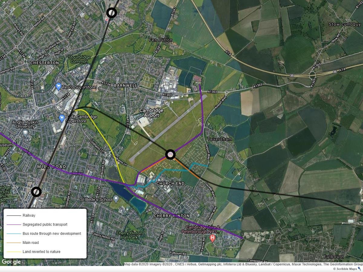
The Tins
This is a valuable cycling route, compromised by the narrow bridge over the railway, which has blind turns either side and steep ramps. The minimum intervention must be to replace and re-orientate the bridge so that it can safely carry a large volume of people walking and cycling. Until then, we recommend installing mirrors on the blind corners.
If a busway is constructed through The Tins, we would want reassurance that the cycle/footway will also be widened and remain open for the duration of the construction period, as there are no convenient alternative cycling or walking routes.
East of Cambridge
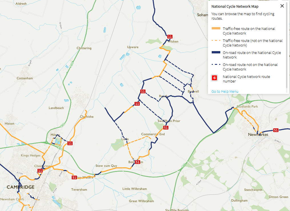
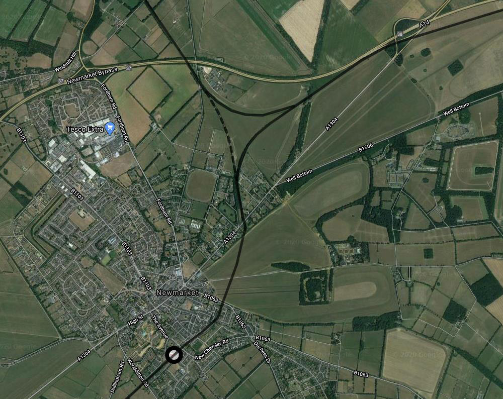
Demand for good cycling infrastructure has been evident during the pandemic, when use of the Wicken Vision paths and National Cycle Route 51 (see Figure 3) has increased substantially – as has the number of people cycling on pavements in villages. The need for safe, convenient cycle links east of Cambridge extends well beyond the planned Swaffham Greenway. Burwell is the fourth largest settlement in East Cambridgeshire with a growing population, but has no protected cycleways linking it to Cambridge or Newmarket.
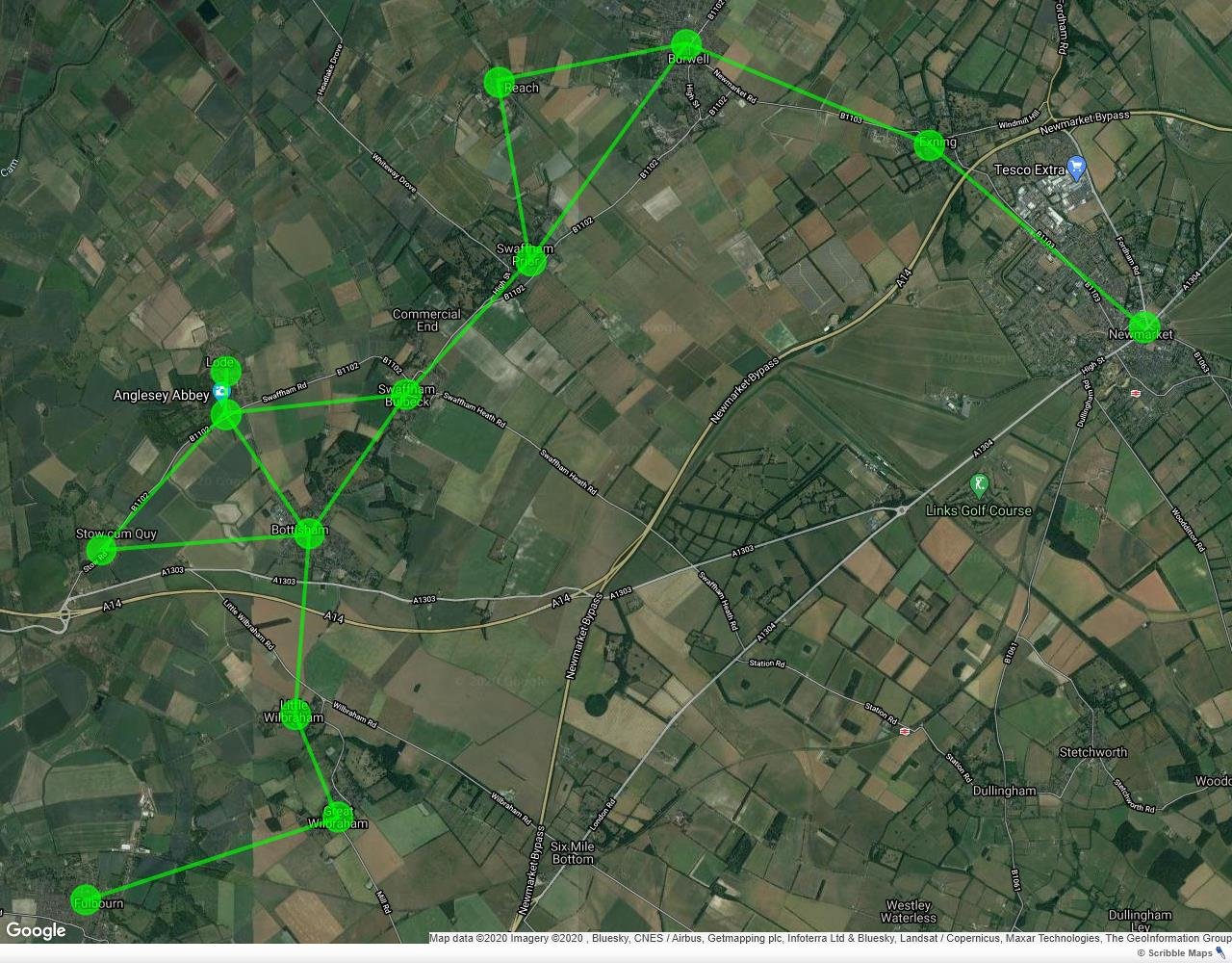
As part of the Eastern Access programme, we would like GCP to start planning, with East Cambridgeshire and Forest Heath District Councils, the rest of the cycle network, linking all the villages between Cambridge and Newmarket (see Figure 4).
Park & Ride
We are opposed to the relocation of the Newmarket Park & Ride (PR.02 & PR.03 & PR.04). Instead, we want to see travel hubs – not huge car parks – built in all the larger villages, with safe foot/cycleways from the surrounding areas.
Paired with ‘express’ bus services that run along direct routes with limited stops, these would give many more people a way to get to Cambridge and neighbouring villages without needing a car. Add interchange hubs within Cambridge and rural services can link with higher-frequency city services, giving people convenient access to all parts of the city.
We support the proposal for additional Park & Ride bus services (BS.02 & BS.03), but we want these to be integrated with rural bus services with no fare penalty for interchanging. We want to see all Park & Rides developed as interchange hubs, connecting rural, city and intercity services. We also want land to be reserved for future interchange hubs in the most appropriate locations in and around the city, such as railway stations, the Girton Interchange, and other intersections of major transport routes.
As a concept, park-and-ride was an appropriate, indeed progressive, solution in the 1990s. That is no longer the case as priorities have changed, in particular the urgent need to decarbonise transport through a rapid and sustained reduction in vehicle-miles. Driving to the edge of Cambridge in order to catch a bus into the city centre still requires a car and makes little difference to carbon emissions. (The Hauxton car park has been shown to increase emissions.) Only by cutting out the car trip can emissions be reduced significantly.
Public transport from east of Cambridge
GCP is looking down the wrong end of the telescope, focusing mainly on small time savings for buses within Cambridge, but ignoring the long journey times and infrequent services from the market towns and villages from which people are travelling.
Bus services wind their way through the villages, taking an hour and twenty minutes between Newmarket and Cambridge bus stations. If you miss the 06:59 from Newmarket, the next service doesn’t arrive in central Cambridge until just before 10am. Coming from Bury St Edmunds, there are just two express services in the morning and one returning in the evening; otherwise, you have to change at Newmarket – without a guaranteed connection – making the journey nearly two hours each way.
Train services are not much better: they are only hourly from Bury St Edmunds and Newmarket, and two-hourly from Dullingham and Kennet. Onward bus connections from Cambridge station to, say, the Science Park, Biomedical Campus or West Cambridge, add considerable time and cost to an already inconvenient journey.
This is only partially resolved by reducing journey times between the Stow-cum-Quy A14 interchange and central Cambridge. In any case most of the benefit being proposed cannot be realised until the airport is redeveloped, which might be ten years hence.
We would like to see proposals from GCP for new bus services, and travel hubs in the larger villages to provide convenient and safe access to express bus services that:
- Follow a direct route to Cambridge and are time-competitive with driving.
- Offer quick interchange opportunities, e.g. at rail stations and Newmarket P&R, to reach multiple destinations in and around Cambridge.
- Have simple and attractive fares that include connecting services.
Newmarket Road
We support the implementation of an integrated traffic management system (ITS.01).
We support the reallocation of space and signal time from general traffic to buses, cycles and pedestrians. This should be prioritised in accordance with the user hierarchy set out in local transport strategies:
- Provide safe pavements throughout and pedestrian crossings on key desire lines.
- Provide protected cycle lanes (AT.01 & AT.02) and junctions along the length of the road.
- Reallocate carriageway to a bus lane where sufficient space remains.
Bus lanes in the city should be regarded as short-term measures while demand-management and other incentives are introduced. Once new options and incentives achieve enough modal shift from single-occupancy cars to active, public and shared transport to eliminate congestion on Newmarket Rd, bus lanes may be reallocated to public realm, for instance as an avenue of trees between the carriageway and cycleway.
Ideas for the replacement of the East Rd–Elizabeth Way roundabout (JC.01) should be developed through engagement and workshops led by Cambridge architects, who have long used this site as an imaginative exercise in how to improve the public realm.
Coldhams Lane
We are unclear what is proposed by “carriageway widening along Coldhams Lane” (HW.05). This could provide benefit if it comprised a westbound bus lane with a flow-control gate at the point where it merges with the general traffic lane before the railway bridge.
The Land North of Cherry Hinton development and future airport redevelopment provide a unique opportunity to re-route through-traffic away from the north of Cherry Hinton (Church End) by creating a bypass link through undeveloped land between Coldhams Lane and Gazelle Way (see Figure 7). This would allow the eastern end of Coldhams Lane and Teversham Drift to be treated as part of a Low Traffic Neighbourhood, with significantly more priority given to walking and cycling.
Mill Road
Retaining the bus gate on Mill Rd bridge (BG.02) would improve safety for people walking and cycling, as it reduces conflicts on the roads and at major junctions, such as Devonshire Rd/Kingston St. It will also help make Mill Rd a more inviting leisure destination. However, issues would still remain for Mill Rd:
- No cycle route to/from Parkers Piece.
- No cycle route to/from Anglia Ruskin University’s main entrances.
- Motor traffic west of Tenison Rd will increase significantly once station pick-ups/drop-offs return to pre-pandemic levels.
- Motor traffic between Brooks Rd and Coleridge Rd remains relatively high (around 4,000 vehicles/day).
These need to be addressed as part of a wider vision and strategy for Mill Rd as a major city destination, a safe place to walk and cycle, and a key public transport route.
GCP needs to engage directly with businesses in the city, including on Mill Rd, to accelerate development of zero-carbon delivery services so that customers do not need to bring their own car to shop in Cambridge.
A bus stop on the bridge could be linked by an upgraded stairway to the Chisholm Trail, 550m to the north of Cambridge station entrance. This would enhance the attractiveness of the Citi 2 and proposed new Park & Ride bus service via Mill Rd (BS.02).
Busway via The Tins
We support further work on the costs and benefits of creating a bus-only link between Coldhams Lane and Mill Rd via The Tins. Combined with retention of the bus gate on Mill Rd, this would create a congestion-free route from Coldhams Lane to central Cambridge. If this is in future extended through the airport site to the Airport Way roundabout on the A1303, buses would have a 5.5km congestion-free route into central Cambridge without any need for tunnelling or other engineering works.
The Tins route would also provide car-free access to/from:
- Church End (north Cherry Hinton)
- The Land North of Cherry Hinton development
- Future airport development
- Holiday Inn Express hotel
- David Lloyd gym
- Coldhams Lakes and country park (as proposed by Anderson Group)
- Other retail and leisure sites on Coldhams Business Park
- New housing on and around the airport site
However, consideration must be given to:
- The environmental and ecological impacts of building and operating the busway
- The social impact on residents of Brookfields: noise, pollution (from diesel buses) and loss of on-street parking
Railway
We support reinstating the twin track between Coldhams Lane Junction and Newmarket (RA.02), which we understand is being planned as part of East West Rail in the 2030s, if a realignment of the line is not deemed viable (see below). In either case, we would like to see GCP work with the rail industry to install enough new track to enable a reliable half-hourly service between Cambridge and all stations out to Bury St Edmunds as soon as practicable.
With the new station at Soham due to open at the end of 2021, we would like GCP and the Combined Authority to accelerate discussions with the rail industry about reinstating the chord connecting Newmarket directly with Soham (Figure 5) and reinstating a second track and platform at Newmarket station. This would enable direct services to run between Ely, Soham and Newmarket. With a half-hourly service from Newmarket to Cambridge, waiting times to change trains at Newmarket would be tolerable.
New stations
We support the proposal for a new parkway station at Six Mile Bottom (RA.07), with direct access from the A11, as this would provide a railhead for a large catchment area.
We support the proposal for a new station where Fulbourn Old Drift used to cross the railway line (RA.05) if and only if the railway alignment will not change in future (see below). If it will change, then the technical requirements for a station here, whether for a light rail or BRT station, will be different. As a railway station, it would serve Fulbourn, Capital Park, Fulbourn Hospital, Ida Darwin Hospital, Peterhouse Technology Park, and accessible from most of Cherry Hinton, Fulbourn and Teversham. If it were a tram or bus stop, then other stops to the east and west would serve some of those locations better.
We do not believe that the proposed location for a Cambridge East station (RA.04) is appropriate: it is not convenient to any major employment sites, and would be on land that should be protected for nature (which we understand is part of emerging plans for the Land South of Coldhams Lane).
Re-alignment of the railway line
We support further work on options RA.01 and RA.03 for realigning the Newmarket railway line, even though GCP have rejected these. The Options Appraisal Report states:
The realignment of the existing Cambridge–Newmarket line could generate significant benefits, for all modes of travel. Rail journey times and capacity would both benefit, as would the potential for the provision of East-West Rail in the future. At a more local level, the realignment would enable the removal of the level crossings which currently cause delays to general traffic and a safety concern for all road users.
Further benefits include:
- The existing railway alignment could instead carry a high-frequency local public transport service, based on light rail or electric buses.
- If the existing alignment were connected with The Tins busway, that would create an almost completely congestion-free route between Cambridge city centre and Capital Park, Fulbourn Hospital, Ida Darwin Hospital, Peterhouse Technology Park and Cambridge Steiner School.
- A more northerly alignment for the railway would provide a better location for a Cambridge East station, which could be at the centre of a new business and leisure zone within the airport development.
- Four level crossings could be avoided: Cherry Hinton High St, Gazelle Way, Teversham Rd and Fulbourn Station Rd. Frequent closure of these crossings in future, as East West Rail and more freight services use the line, will have a negative social and economic impact.
- Removing freight trains from the centre of Cherry Hinton would remove a major source of noise, vibration and, for as long as diesel locomotives are used, air pollution. All of these would otherwise significantly reduce the quality of life of people living by the railway line.
- Releasing land in the middle of Coldhams Common would reduce the severance effect of the existing railway line, improving access and usability of the common. The existing line between Coldhams Lakes and close to Coldhams Lane junction could be released in a land-swap to ensure no net loss in ecologically valuable land.
- Being able to dismantle the bridge over Coldhams Lane would create space for protected cycle lanes to continue to the roundabout.
We urge GCP to engage with the East West Rail Consortium and Marshall to develop a strategy and a plan for realigning the railway. From this will follow much else about the design of the airport redevelopment and public and active transport links through the site.
We have suggested a slightly different alignment to RA.03, which could enable the railway and an access road from Gazelle Way roundabout to be run together in a cutting or cut-and-cover tunnel to reduce the severance and noise impacts (see Figure 6).
If this option is likely to progress, then it may not make economic sense to build a busway bridge over the railway line in the short term, as this would no longer be required once the railway line is vacated.
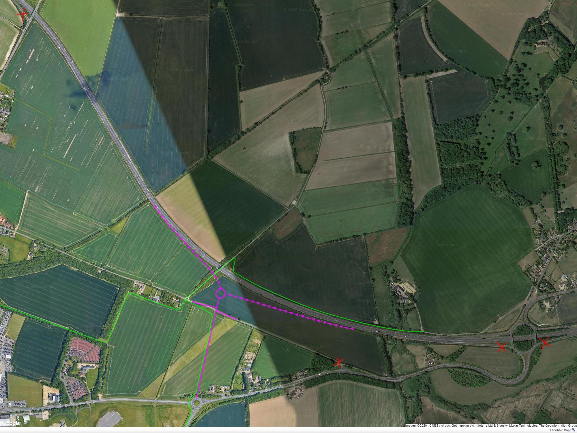
A14 junctions
Although we agree with the ambition to reduce traffic on Ditton Lane, closing access to/from the A14 at Junction 34 (JC.08) would have a disproportionately negative impact on residents in Horningsea. It would also divert some traffic bound for the south-east of Cambridge, including the Biomedical Campus, through the centre of Cambridge (via Milton Rd, Elizabeth Way, East Road and Hills Road).
We recommend Highways England and the Highway Authority consider replacing the westbound on and off slips from both junctions 34 and 35 with a new access from north of Airport Way (see Figure 7). This would remove much of the traffic from the A1303 between Airport Way and the Quy interchange, obviating the need to widen this road (HW.01 & BW.04), which would have more significant ecological impacts. Traffic, including buses, from Burwell, Swaffhams, Bottisham and Stow-cum-Quy would experience less congestion as it would not be mixing with A14 traffic in and out of Cambridge.
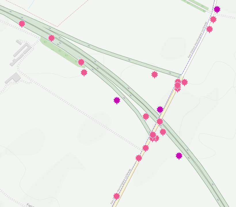
The change would also remove some of the traffic on Ditton Lane and Horningsea Rd, reducing congestion at the Newmarket Rd junction. Closure of the westbound slip at junction 34 would eliminate a right turn, improving safety in a collision hotspot (see Figure 8).
There is also an opportunity to create a new cycle route between the Marshall Millennium cycleway behind Newmarket P&R and Stow-cum-Quy via Low Fen Drove Way bridge.
In the longer term it may be desirable to replace both junctions 34 and 35 with:
- An E-W junction at the end of a northward extension of Airport Way.
- New all-ways junction between the A14, A11 and A1303. This would, amongst other benefits, increase the resilience of the strategic road network.
The best public transport in and out of the city to suggested travel hubs would be railed ie trams, as they can be safely modernised eventually to be driverless.
Trams when on roadways should be limited to city roads wide enough to take some motor traffic.
Any P&R bus routes, in the meantime, should be seen as temporary and be limited to where tramways could be built later. Improvements suitable for tramways could be made over time.
There are several roads wide enough for this: Hills Road, Newmarket Road, East Road , Milton Road, Madingley Road, Chesterton Road, Victoria Avenue, Elizabeth Way, Huntingdon Road. New Square could be converted into a terminus for these services.
Mill Road is too narrow for a busway as high speed buses at peak hours would endanger other users. The bus gate divides what is seen as one community into two and should be removed.
Other improvements can be made to Mill Road with consultation as has happened over the years in the side streets off it but it should be mainly used by service traffic, local traffic, taxis and disabled drivers. There are already two cycle bridges available nearby.
Leave the Tins alone except to improve the bridge as suggested. Part of the airport was originally on Coldham’s Common but taken over by Marshall in WW2. Return it and make the rest of the airport part of the common and don’t build on it until the increasing water supply problem is solved. Stop ogling green space and dreaming of covering it in tarmac and bricks even if it does fill a lot of pockets with cash.
Thanks.